
Reports
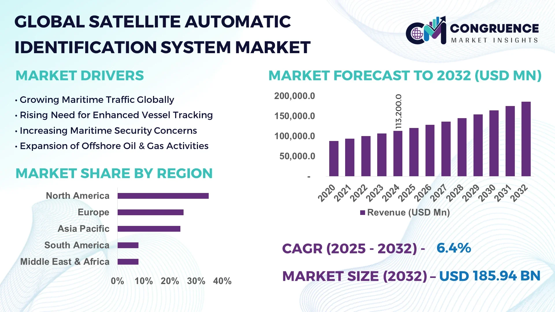
The Global Satellite Automatic Identification System (S-AIS) Market was valued at USD 113.2 Billion in 2024 and is anticipated to reach a value of USD 186.5 Billion by 2032, expanding at a CAGR of 6.4% between 2025 and 2032.
North America currently dominates the S-AIS market, primarily due to its advanced technological infrastructure, significant investments in maritime surveillance, and stringent regulatory frameworks. The region's emphasis on enhancing maritime domain awareness and security has led to widespread adoption of S-AIS technologies across both commercial and defense sectors.
The S-AIS market is experiencing robust growth, driven by the increasing need for real-time vessel tracking, maritime safety, and environmental monitoring. The integration of S-AIS with other technologies, such as AI and machine learning, is enhancing data analytics capabilities, enabling predictive analysis of vessel movements and identification of unusual activity patterns. Furthermore, the deployment of nano-satellites and satellite constellations is improving the frequency and coverage of S-AIS data collection, resulting in near-real-time monitoring. These advancements are expanding the applications of S-AIS beyond traditional maritime monitoring to include fisheries management, environmental conservation, and offshore energy operations.
Artificial Intelligence (AI) is significantly transforming the Satellite Automatic Identification System (S-AIS) market by enhancing data processing, predictive analytics, and maritime situational awareness. AI algorithms can process vast amounts of AIS data to identify patterns and anomalies in vessel movements, improving the detection of illegal activities such as smuggling and unauthorized fishing. Furthermore, AI-driven predictive models help in forecasting potential collisions and optimizing shipping routes, thereby increasing the safety and efficiency of maritime operations. This integration of AI boosts the operational capabilities of maritime surveillance and opens up new avenues for innovation in the S-AIS market, attracting investments and fostering the development of advanced maritime analytic solutions.
“In November 2024, a major maritime data analytics firm announced the acquisition of a ship tracking company, granting it access to a proprietary satellite and AIS data stream capable of tracking global ship movements every 15 minutes. This deal raised antitrust concerns among industry stakeholders, especially regarding the potential restriction of data access to other commercial users and competitors. The event highlighted the growing importance of real-time, high-frequency satellite AIS data and its influence on commercial decision-making, government surveillance, and the competitive landscape within maritime analytics.”
The increasing global maritime traffic has heightened the need for advanced tracking systems to ensure safety and security at sea. S-AIS provides real-time data on vessel positions, identities, and navigational statuses, which is crucial for preventing collisions, managing traffic, and responding to emergencies. The technology's ability to monitor vessels beyond the range of terrestrial AIS systems makes it indispensable for comprehensive maritime surveillance. Governments and maritime organizations are investing in S-AIS to enhance their capabilities in monitoring and securing vast oceanic regions.
While S-AIS offers extensive coverage, it faces challenges related to data accuracy and reliability. Factors such as signal interference, atmospheric conditions, and the presence of "spoofing" activities can affect the precision of vessel location data. Additionally, the management and storage of large volumes of S-AIS data, often coming from diverse sources, pose complexities for data processing and analysis. Ensuring cybersecurity and preventing unauthorized access to critical vessel information is also a major concern for stakeholders. Balancing the need for high data quality with the cost of satellite bandwidth and processing remains a challenge for many service providers in this market.
The integration of S-AIS data with other geospatial intelligence platforms presents significant growth opportunities. Combining vessel tracking data with weather patterns, ocean currents, and other environmental data enhances maritime domain awareness. The development of new data analytics and machine learning tools opens the door for predictive analysis and customized services based on S-AIS data. There's an increasing demand for real-time monitoring of global supply chains and tracking of cargo transportation, creating new use cases for the technology. New business models centered around subscription-based S-AIS data services are also emerging, which helps to streamline accessibility to smaller stakeholders.
As the S-AIS market grows, ensuring the security of transmitted data becomes increasingly important. Cybersecurity threats pose risks to the integrity and confidentiality of AIS data, which can be exploited for malicious purposes. Additionally, the vast amount of data generated by S-AIS systems requires robust infrastructure for storage, processing, and analysis. Organizations must invest in advanced data management solutions to handle the influx of information effectively. Developing standardized protocols and frameworks for data sharing and security is essential to address these challenges and maintain stakeholder trust.
Rise in Modular and Prefabricated Construction: The adoption of modular construction is reshaping the demand dynamics in the S-AIS market. Pre-integrated satellite systems and prefabricated maritime surveillance kits are enabling faster deployment and reduced installation time. This trend is gaining momentum in regions focused on rapid port development and coastal surveillance enhancements. Such innovations are helping reduce labor dependency and speeding up response mechanisms in security and rescue operations.
Integration of AI and Machine Learning: The integration of AI and ML is revolutionizing how maritime data is processed. Predictive modeling using historical AIS data allows for proactive decision-making in shipping logistics. Machine learning algorithms are being trained to detect suspicious maritime behavior and provide automated alerts. These features are especially critical for authorities monitoring vast oceanic areas with limited personnel.
Expansion of Satellite Constellations: The launch of new satellite constellations is increasing global coverage and reducing data latency in maritime monitoring. This is particularly beneficial in tracking vessels in remote ocean zones where terrestrial AIS is ineffective. The resulting improved visibility enhances maritime safety, enforcement of international waters, and response times for search-and-rescue operations.
Emergence of Subscription-Based Data Services: With more maritime stakeholders seeking real-time insights without heavy infrastructure investment, subscription-based models are gaining traction. These services offer access to curated AIS data streams tailored to specific needs like fishing fleet management, cargo tracking, or environmental monitoring. This flexible approach is helping small to mid-sized operators join the digital maritime transformation.
The Satellite Automatic Identification System (S-AIS) market is segmented into types, applications, and end-users, each playing a critical role in shaping industry growth. In terms of types, the market is divided into Class A and Class B transponders, serving different vessel sizes and operational requirements. Applications range from fleet management and vessel tracking to maritime security and environmental monitoring. Among end-users, both commercial and government sectors significantly contribute to the market’s expansion. Commercial shipping companies rely on S-AIS for operational efficiency and compliance, while government agencies focus on maritime surveillance and safety. These segmentation insights are crucial to understanding how various market forces drive demand across diverse maritime sectors.
The S-AIS market comprises two main types: Class A and Class B transponders. Class A transponders hold the largest market share due to mandatory regulations for large commercial and passenger vessels. These systems provide high-frequency data updates and are essential for congested shipping routes where safety and compliance are paramount. Class A units are known for their robust capabilities in transmitting voyage-related data, making them indispensable for international maritime operations.
Class B transponders, designed for smaller and recreational vessels, are emerging as the fastest-growing segment. These transponders are more cost-effective and easier to install, appealing to smaller commercial operators, fishing fleets, and leisure craft. With increasing global emphasis on comprehensive vessel visibility and maritime safety, more non-mandated vessels are voluntarily adopting Class B systems. The surge in regional fishing activity and coastal transport is accelerating the demand for this category, especially in developing maritime economies.
Key applications of S-AIS include fleet management, vessel tracking, maritime security, search and rescue operations, and environmental monitoring. Fleet management currently accounts for the largest share, driven by the shipping industry’s focus on improving route efficiency, fuel optimization, and cargo tracking. Real-time insights provided by S-AIS help reduce operational costs and enhance asset utilization.
Vessel tracking stands out as the fastest-growing application segment. As piracy, smuggling, and unauthorized fishing persist in several regions, real-time vessel tracking has become a critical component for enhancing maritime situational awareness. Government authorities and maritime organizations increasingly rely on S-AIS to monitor vessel movements in restricted and high-risk zones. Furthermore, advancements in satellite coverage and tracking resolution are boosting the effectiveness of these systems, thereby encouraging adoption in new geographies and use cases.
The end-user landscape includes commercial and government sectors. The commercial sector holds the largest share, owing to the high adoption of S-AIS by cargo shipping companies, logistics firms, and maritime operators. These organizations depend on S-AIS for regulatory compliance, route planning, and cargo monitoring. The ability to integrate S-AIS with onboard navigation systems and port management platforms also contributes to its widespread use.
The government sector is the fastest-growing end-user segment, driven by rising investments in national security, border control, and marine conservation. Government agencies utilize S-AIS for tasks such as coast guard patrols, maritime domain awareness, and illegal fishing prevention. National defense and naval operations are also incorporating S-AIS for enhanced threat detection and vessel identification. The increasing need for secure maritime borders and real-time situational awareness is prompting a surge in government procurement of S-AIS technologies.
North America accounted for the largest market share at 34.8% in 2024; however, Asia-Pacific is expected to register the fastest growth, expanding at a CAGR of 7.2% between 2025 and 2032.
North America's lead stems from widespread adoption of maritime safety technologies and strong port infrastructure. Meanwhile, Asia-Pacific's rapid expansion is driven by its booming shipping industry, growing port digitization, and increased focus on vessel monitoring and environmental compliance. Both regions exhibit strong investment momentum in real-time maritime visibility, positioning them as critical contributors to global market development.
Advanced Maritime Surveillance and Technology Integration
In 2024, North America's Satellite Automatic Identification System market is characterized by high integration of satellite-based tracking systems in maritime operations. The region benefits from extensive coastal and inland waterway networks that require continuous monitoring. National security protocols emphasize real-time ship positioning and tracking, which has spurred the adoption of high-resolution AIS systems. Commercial fleets are also leveraging AIS to enhance fleet safety, efficiency, and compliance with port authority requirements. Major maritime hubs have upgraded to next-generation AIS, supporting automation and predictive analytics.
Focus on Regulatory Compliance and Maritime Safety
Europe continues to lead in policy-driven adoption of satellite AIS technologies. In 2024, countries across the region deploy AIS systems for both commercial shipping oversight and environmental compliance. Use of these systems for emissions monitoring, ballast water tracking, and ship performance evaluation is expanding. Enhanced interoperability between maritime safety agencies has also improved vessel identification accuracy in crowded sea lanes. Investments in green shipping corridors and sustainable marine transportation have reinforced the role of AIS in tracking and operational transparency.
Rapid Expansion through Maritime Infrastructure Development
Asia-Pacific is seeing rapid growth in the S-AIS market due to the region’s position as a global shipping hub. In 2024, regional governments are investing in AIS infrastructure to monitor shipping lanes, prevent collisions, and improve port throughput. Maritime modernization programs in countries like China, South Korea, and Japan are equipping fleets with satellite-enabled AIS for better tracking and analytics. The rise of smart ports and automated port operations is increasing demand for reliable, continuous ship-to-shore communications, for which AIS plays a pivotal role.
Focus on Coastal Monitoring and Sustainable Fisheries
South America is expanding its S-AIS capabilities to improve oversight of maritime zones. In 2024, coastal nations are increasingly relying on AIS to monitor fishing activities and control illegal vessel movement. Economic reliance on commercial fisheries and ocean-based trade is driving this trend. Governments are deploying new systems to track fleet movements in remote ocean regions, helping to regulate resource usage and reduce smuggling. Enhanced use of AIS also supports environmental assessments related to marine biodiversity and oceanographic changes.
Growing Investment in Maritime Domain Awareness
In 2024, Middle East & Africa are enhancing their maritime domain awareness through satellite AIS deployment. Strategic maritime routes and expanding port infrastructure in this region require precise ship traffic management. Nations are using AIS data to track cargo shipments, enforce territorial waters, and mitigate threats such as piracy. With an increase in international trade through Red Sea and Gulf routes, ports in UAE, Saudi Arabia, and South Africa are improving maritime security and port logistics through real-time tracking and AIS-linked systems.
United States: Leads globally due to extensive investment in maritime surveillance infrastructure and widespread AIS use in both commercial and defense applications.
China: Ranks second, fueled by large-scale shipbuilding, port modernization, and mandatory AIS integration across commercial fleets.
The Satellite Automatic Identification System (S-AIS) market is marked by strong competition, with several key players actively investing in technology upgrades, constellation expansion, and AI integration to enhance maritime tracking services. The competition is driven by increasing global maritime trade and the need for better vessel monitoring and navigation safety. Companies are adopting multi-sensor data fusion and cloud-based analytics platforms, enhancing the accuracy and timeliness of AIS data. Strategic partnerships and M&A activities are enabling firms to broaden their geographic footprint and technological capabilities. Additionally, companies are focusing on vertical integration, offering both AIS transceivers and satellite services, enabling better control over quality and performance. The competitive environment is accelerating innovation, making real-time global tracking and predictive analytics the new benchmarks in maritime surveillance.
ORBCOMM
Spire Global
Kongsberg Gruppen
Saab AB
Furuno Electric Co. Ltd.
L3 Technologies Inc.
Garmin Ltd.
Japan Radio Company Ltd.
True Heading AB
CNS Systems AB
Wärtsilä OYJ Abp
ComNav Marine Ltd.
Technological innovations are rapidly transforming the Satellite Automatic Identification System (S-AIS) market. Integration of Synthetic Aperture Radar (SAR), optical sensors, and RF detection with AIS data enables accurate vessel identification even when AIS transponders are switched off. The use of Low Earth Orbit (LEO) satellite constellations ensures near-real-time vessel tracking, which is especially vital for high-traffic maritime zones and remote ocean areas. This provides improved vessel density monitoring, route optimization, and emergency response.
Artificial Intelligence (AI) and Machine Learning (ML) algorithms are now embedded in S-AIS platforms to perform advanced analytics like anomaly detection, illegal fishing pattern recognition, and behavioral tracking. These technologies support security agencies, coast guards, and shipping companies in taking proactive measures based on predictive insights.
Enhanced AIS (e-AIS) further strengthens communication protocols by increasing bandwidth and ensuring encrypted data sharing for sensitive maritime operations. In parallel, cloud-based platforms are being deployed to support multi-user data access, API integration, and real-time dashboards that support global maritime traffic management. Together, these advancements are pushing the industry toward smarter and more secure maritime domain awareness.
In June 2024, a new AIS-equipped satellite was launched to improve ship tracking capabilities and maritime domain awareness globally, contributing to better navigation and safety operations.
In December 2024, a major acquisition deal valued at over $240 million was finalized to consolidate AIS data analytics and satellite communication capabilities, enabling broader service offerings and better integration.
In October 2024, increased incidents of satellite navigation spoofing were reported in maritime zones, affecting AIS signal accuracy. This prompted industry-wide discussions on AIS data integrity and maritime cybersecurity.
In 2023, a major S-AIS operator unveiled an upgraded real-time vessel tracking platform that integrates AI analytics, offering real-time global maritime visibility for commercial and governmental stakeholders.
The Satellite Automatic Identification System (S-AIS) market serves critical functions across maritime logistics, defense, security, and environmental monitoring. Designed to track and monitor vessels beyond coastal regions, S-AIS enables seamless global visibility, even in remote oceanic zones. It supports a wide array of applications such as vessel collision avoidance, route planning, illegal fishing detection, and maritime border security.
The market is segmented based on system type (active, passive, and hybrid), application (fleet monitoring, intelligence & surveillance, search & rescue), and end-user industries including commercial shipping, defense, and fisheries. With increasing sea trade and regulatory enforcement in Exclusive Economic Zones (EEZs), the market is witnessing elevated demand across developed and developing maritime nations.
Technological advancements such as real-time analytics, satellite miniaturization, cloud-based AIS data platforms, and AI-enhanced monitoring systems are significantly broadening the scope of S-AIS usage. The continuous expansion of LEO satellite constellations and growing collaboration between private players and maritime authorities further ensures the S-AIS market’s long-term relevance and scalability.
| Report Attribute / Metric | Report Details |
|---|---|
| Market Name | Global Satellite Automatic Identification System Market |
| Market Revenue (2024) | USD 113.2 Billion |
| Market Revenue (2032) | USD 186.5 Billion |
| CAGR (2025–2032) | 6.4% |
| Base Year | 2024 |
| Forecast Period | 2025–2032 |
| Historic Period | 2020–2024 |
| Segments Covered |
By Type
By Application
By End-User
|
| Key Report Deliverables | Revenue Forecast, Growth Trends, Market Dynamics, Segmental Overview, Regional and Country-wise Analysis, Competition Landscape |
| Regions Covered | North America, Europe, Asia-Pacific, Middle East & Africa, South America |
| Key Players Analyzed | ORBCOMM, Spire Global, Kongsberg Gruppen, Saab AB, Furuno Electric Co. Ltd., L3 Technologies Inc., Garmin Ltd., Japan Radio Company Ltd., True Heading AB, CNS Systems AB, Wärtsilä OYJ Abp, ComNav Marine Ltd. |
| Customization & Pricing | Available on Request (10% Customization is Free) |