
Reports
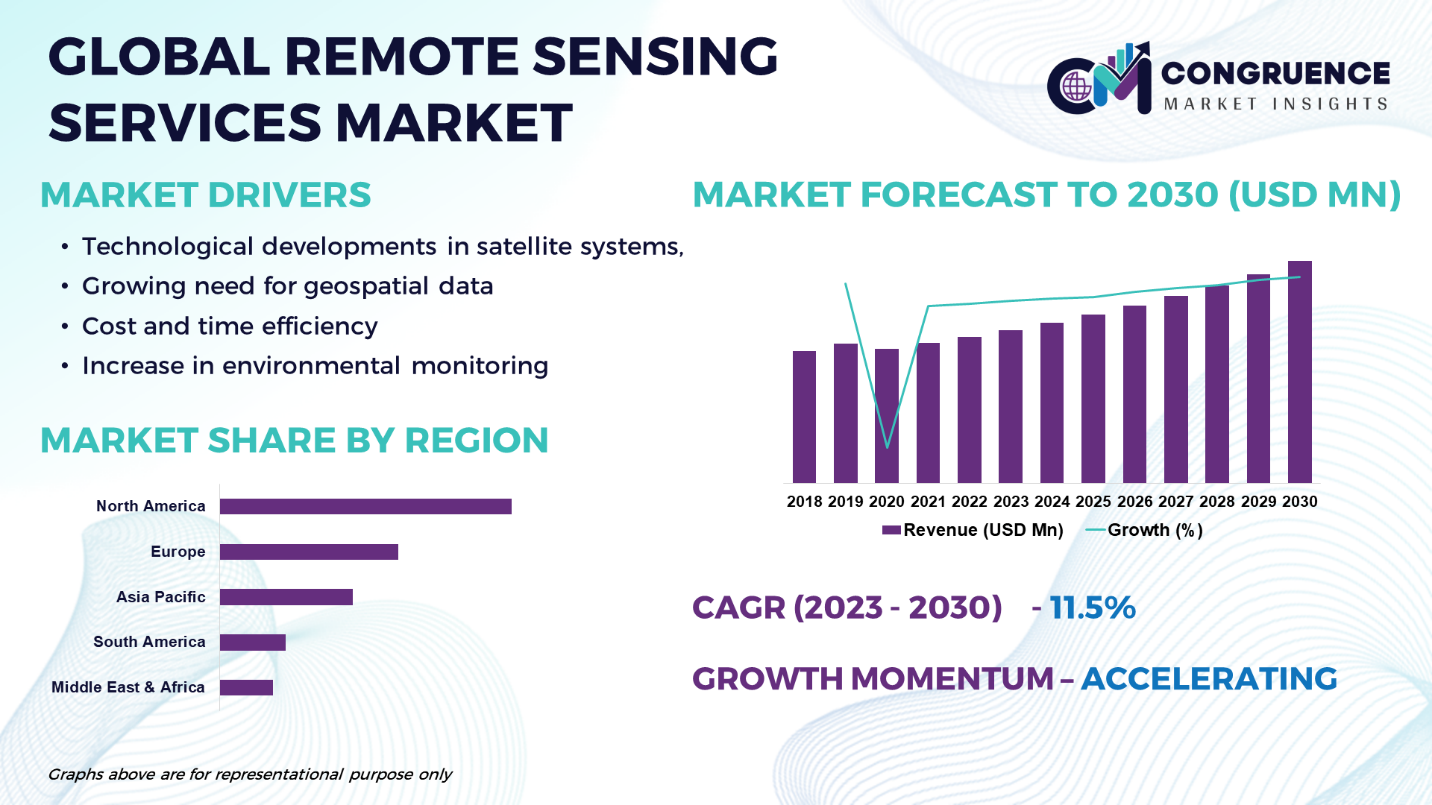
With remote sensing services, information about an object or phenomena is collected and analyzed using gadgets that are not in close proximity to the subject. This covers technology such as LIDAR, radar, satellites, and aerial photography, among others. Comparing remote sensing to ground surveys, there are a number of benefits, including cost effectiveness, real-time data, and vast coverage. The demand for enhanced monitoring and surveillance across industries, the growing use of location-based services, and the expansion of military intelligence and defense industry applications are the main factors driving the market's growth. The growing need for environmental monitoring is projected to drive considerable expansion in the global remote sensing services market. Through the use of remote sensing technology, data and information about the Earth's surface can be gathered without making direct physical contact. This makes it possible to monitor environmental changes and their effects in an efficient and economical manner. Remote sensing services are being used more often in a variety of industries, including forestry, water resource management, and agriculture, as a result of greater awareness of the need for sustainable resource management and conservation. The Global Remote Sensing Services Market is expected to expand at a CAGR of 11.5% between 2023 and 2030.
Remote Sensing Services Market Major Driving Forces
Technological Developments in Satellite Systems: The capabilities of remote sensing services have been improved by advances in satellite technology, including higher spatial resolution, better spectral bands, and higher revisit rates. The need for remote sensing services is being driven by these advances, which make it possible to collect and analyze data with greater accuracy.
Growing Need for Geospatial Data: Sectors such as infrastructure development, urban planning, and agriculture are experiencing a sharp rise in the demand for geospatial data. Demand for remote sensing services has surged because they offer useful data and insights for accurate decision-making in various areas.
Cost and Time Efficiency: Compared to conventional data collection techniques, remote sensing services are both more affordable and time efficient. Organizations may collect vast amounts of current data more quickly by using satellite images or aerial photography, which also helps them save money and run more efficiently.
Increase in Environmental Monitoring: The need for remote sensing services has increased due to the growing concern for resource management and environmental sustainability. By monitoring deforestation, changes in land use, pollutant levels, and climatic patterns, remote sensing technology help to inform environmental planning and conservation initiatives.
Remote Sensing Services Market Key Opportunities
Interaction with Artificial Intelligence (AI) and Machine Learning (ML): Combining Al and ML technology with remote sensing services opens up a world of possibilities for automation and data analysis. Large amounts of remote sensing data can be processed and interpreted by algorithms with high power, which can provide insightful information and enhance decision-making.
Emerging Uses for Autonomous Vehicles: The creation and functioning of autonomous vehicles depend heavily on remote sensing technologies such as LiDAR mapping. Remote sensing service companies can benefit greatly from the expanding markets for drones and self-driving cars.
Increasing Applications in Climate Change Monitoring: Remote sensing services play a critical role in tracking indications of climate change such as variations in plant cover, sea level rise, and temperature patterns. For remote sensing suppliers, the growing emphasis on adaptation and mitigation of climate change offers a major business opportunity.
Remote Sensing Services Market Key Trends
· One prominent development in the market is the combination of Al and ML technology with remote sensing services. The efficiency and accuracy of remote sensing services are increased by the use of Al algorithms, which allow for automated data processing and analysis.
· There is a growing trend toward the use of small satellites, such as CubeSats, for remote sensing purposes. These satellites provide more accessibility and affordable options for data collecting and monitoring.
· Advances are being made in hyperspectral imaging technology, which records information over a broad spectral range. By offering comprehensive details about the make-up and properties of objects and environments, this technology broadens the range of uses for remote sensing services.
· Drones are being used more and more for remote sensing applications, especially in fields including environmental monitoring, infrastructure inspection, and agriculture. Drones provide mobility, versatility, and the ability to acquire high-resolution data.
· Cloud-based systems are rapidly being used to provide remote sensing services, making data easy to access, analysis that is collaborative, and effective data management and storage possible.
Market Competition Landscape
To improve their service offerings and broaden their market reach, major players in the remote sensing services industry have formed strategic alliances and collaborations. The goal of partnerships between data analytics firms, industry-specific solution providers, and satellite imagery providers is to deliver all-inclusive remote sensing services. Significant developments in sensor capabilities, data analytics, and satellite technology have also enhanced the precision and effectiveness of remote sensing services. The market is growing as a result of better spectral bands, quicker data processing, and higher quality images. Furthermore, industry participants have consolidated their positions in the remote sensing services sector through mergers and acquisitions. They might increase their client base and diversify their services by acquiring specialist businesses or technology. The need for remote sensing services has increased in response to the growing emphasis on sustainability and environmental conservation. Remote sensing technologies are being used by governments, organizations, and industry stakeholders to monitor and manage natural resources more effectively. Prominent players in the market include:
· Maxar Technologies
· Airbus
· Planet Labs
· DigitalGlobe (Maxar Technologies)
· Ball Aerospace
· Hexagon Geospatial
· UrtheCast
· Teledyne Technologies
· BlackSky
· Descartes Labs
· ICEYE
· RapidEye (BlackBridge)
Among leading supplier of geospatial solutions and high-resolution satellite data, DigitalGlobe provides remote sensing services for a range of industries, including disaster relief, agricultural, and military. Conversely, a broad range of remote sensing services, such as satellite imagery, geospatial data, and mapping solutions, are provided by Airbus Defence and Space. Applications for their services include environmental monitoring, infrastructural construction, and agriculture.
|
Report Attribute/Metric |
Details |
|
Base Year |
2022 |
|
Forecast Period |
2023 – 2030 |
|
Historical Data |
2018 to 2022 |
|
Forecast Unit |
Value (US$ Mn) |
|
Key Report Deliverable |
Revenue Forecast, Growth Trends, Market Dynamics, Segmental Overview, Regional and Country-wise Analysis, Competition Landscape |
|
Segments Covered |
· By Service (Data Acquisition/Processing, Consulting Services, Managed Services, Value-added Services, and Others) · By End User Industry (Defense & Security, Agriculture, Energy & Natural Resources Management, Engineering & Infrastructure, Environmental Monitoring, Marine, and Others) · By Technology (GIS/GNSS, Lidar, Drones/UAV, Aerial Photography, Satellite Imagery, and Others) · By Application (Geoengineering & Construction, Disaster Management, Energy Management, Surveillance & Security, Urban Planning & Development, Agriculture Monitoring & Management, and Others) |
|
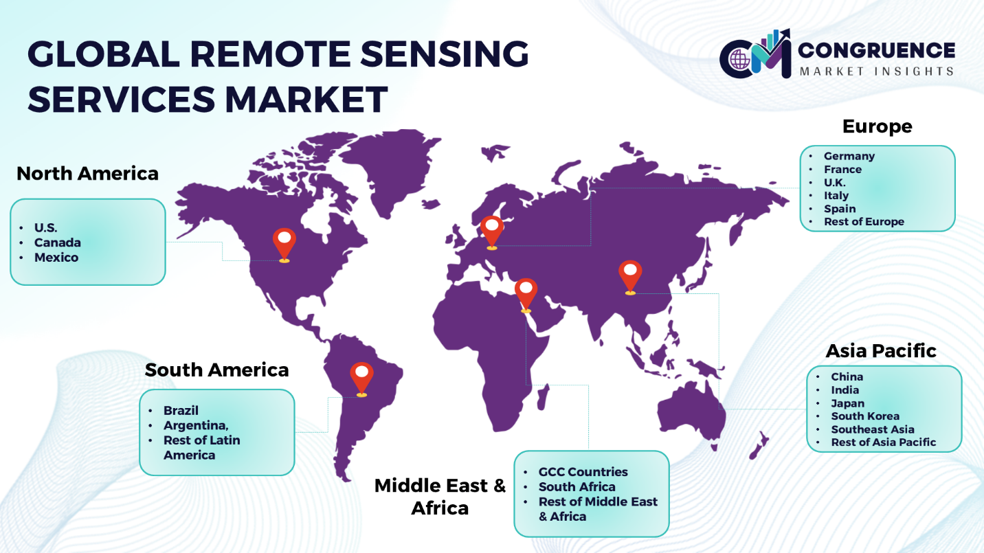
Geographies Covered |
North America: U.S., Canada and Mexico Europe: Germany, France, U.K., Italy, Spain, and Rest of Europe Asia Pacific: China, India, Japan, South Korea, Southeast Asia, and Rest of Asia Pacific South America: Brazil, Argentina, and Rest of Latin America Middle East & Africa: GCC Countries, South Africa, and Rest of Middle East & Africa |
|
Key Players Analyzed |
Maxar Technologies, Airbus, Planet Labs, DigitalGlobe (Maxar Technologies), Ball Aerospace, Hexagon Geospatial, UrtheCast, Teledyne Technologies, BlackSky, Descartes Labs, ICEYE, RapidEye (BlackBridge) |
|
Customization & Pricing |
Available on Request (10% Customization is Free) |