
Reports
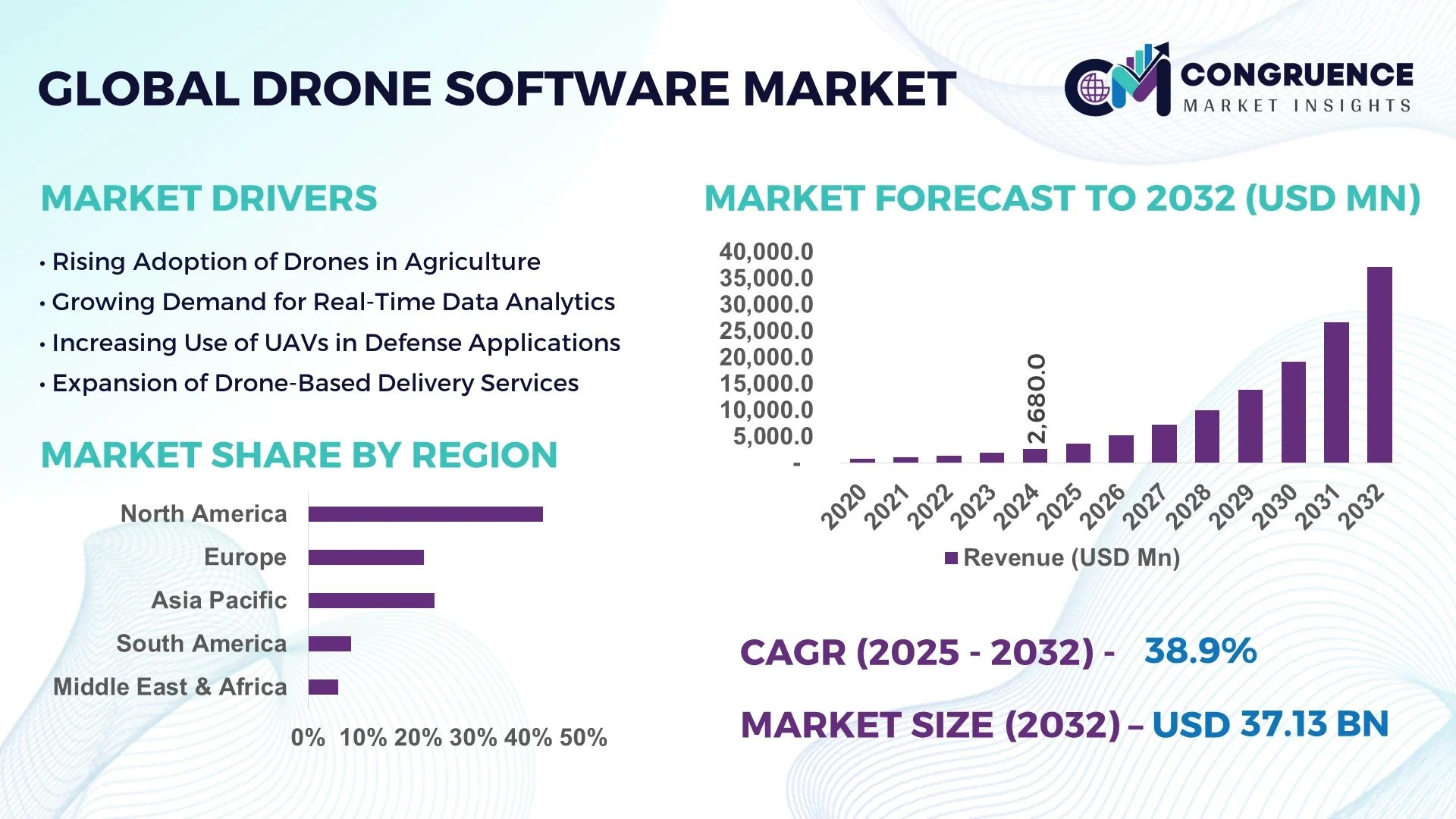
The Global Drone Software Market was valued at USD 2,680 Million in 2024 and is anticipated to reach a value of USD 37,132.37 Million by 2032 expanding at a CAGR of 38.9% between 2025 and 2032.
The United States holds a leading position in the Drone Software Market, with robust investment in drone technology R&D, advanced testing infrastructure, and extensive applications in energy inspections, precision agriculture, and autonomous surveillance, driven by consistent technological innovations in AI-driven analytics and flight control systems.
The Drone Software Market is experiencing rapid advancements across mapping, logistics, agriculture, and defense sectors, driven by increasing demand for precision, automation, and real-time analytics capabilities. AI-integrated drone software is enabling automated flight control, predictive maintenance, and object recognition functionalities, while deep learning algorithms are enhancing post-flight data processing for aerial surveys. Regulatory frameworks in regions such as North America and Europe are supporting the expansion of BVLOS (Beyond Visual Line of Sight) operations, promoting the use of drones for industrial inspections, disaster monitoring, and urban planning. Additionally, market players are integrating 3D modeling, automated mission planning, and swarm technology into their drone software solutions to improve operational efficiency. The rise of green energy projects and environmental monitoring initiatives is further amplifying demand for specialized drone software capable of high-resolution imaging and data analytics for sustainable development projects.
Artificial Intelligence is significantly transforming the Drone Software Market by streamlining operational workflows, enhancing situational awareness, and enabling predictive maintenance in real-time applications. Advanced AI algorithms are now integrated into drone software to optimize flight paths dynamically, reduce energy consumption during missions, and adapt to environmental changes without manual intervention. The Drone Software Market is leveraging computer vision and deep learning to enhance obstacle avoidance, object tracking, and terrain mapping functionalities, providing higher precision in industrial inspections, agriculture yield monitoring, and infrastructure assessment projects. Additionally, AI-powered edge computing within drone software facilitates faster onboard data analysis, reducing dependency on ground control systems and enabling faster decision-making during missions. In urban environments, AI-driven drone software aids in traffic monitoring and emergency response by analyzing real-time video feeds for incident detection and automated reporting. The Drone Software Market is also witnessing integration of natural language processing capabilities for intuitive mission programming, allowing operators to command drones through voice interfaces, simplifying field operations. As regulatory bodies increasingly support autonomous drone operations, AI’s role in managing compliance with airspace regulations and automated flight logging is enhancing operational safety and accountability, further accelerating adoption across commercial and governmental sectors. This AI-led transformation within the Drone Software Market is driving increased deployment across construction, oil and gas, and environmental monitoring, fostering scalable and cost-effective drone operations aligned with evolving industry demands.
“In April 2025, a US-based drone software company integrated a new AI-powered flight risk assessment module into its enterprise drone management software, which has reduced pre-flight assessment times by 70% and increased mission success rates by enabling real-time weather and obstacle data analysis before take-off.”
The Drone Software Market is evolving rapidly, supported by increasing adoption across agriculture, infrastructure, defense, and environmental monitoring sectors. Enhanced integration of advanced analytics, real-time data processing, and AI capabilities into drone software platforms is driving demand for precise mapping, predictive maintenance, and automated inspections. Regulatory support for BVLOS operations and rising investments in smart city initiatives are influencing market expansion while increasing competition is pushing vendors to innovate modular, scalable software solutions. The Drone Software Market is also witnessing a rise in demand for cloud-connected software systems to enable seamless data sharing and mission planning, fostering greater operational efficiency for industrial and governmental end-users.
The integration of AI into drone software is a major driver accelerating the Drone Software Market by enabling autonomous flight operations, reducing human intervention, and optimizing mission efficiency. AI-powered navigation and object detection enhance safety and accuracy during complex missions, benefiting industries like energy, construction, and agriculture. For instance, AI-based route optimization helps drones conserve battery life and complete mapping missions faster, while deep learning algorithms improve post-flight analytics, aiding precision agriculture and land surveys. The increasing use of AI-enabled predictive maintenance within drone software further reduces operational downtime, helping organizations maximize fleet utilization while maintaining high safety standards.
Regulatory complexities in drone operations continue to restrain the Drone Software Market, creating hurdles in the adoption of advanced drone software solutions for commercial and industrial applications. Strict compliance requirements for airspace safety, pilot certifications, and data privacy laws differ significantly across regions, limiting seamless drone deployment. For example, restrictions on BVLOS flights in certain countries prevent the use of drones for automated delivery or large-scale agricultural monitoring, affecting the demand for advanced mission management software. Additionally, frequent updates to drone operation guidelines and the need for real-time software adjustments to align with changing regulations present operational challenges for drone software developers and end-users.
The increasing demand for drones in industrial inspection and infrastructure monitoring presents a significant opportunity for the Drone Software Market. Industries such as oil and gas, energy, and construction are leveraging drones equipped with advanced software for real-time inspections of pipelines, transmission lines, and large construction sites, reducing human risk and inspection costs. The ability of drone software to generate high-resolution imagery, 3D models, and actionable analytics is accelerating its use in predictive maintenance and asset management. With infrastructure development and smart city initiatives rising globally, drone software designed for automated and efficient monitoring is positioned to capture growing opportunities across industrial verticals.
Cybersecurity and data management challenges remain critical concerns for the Drone Software Market, particularly as drones increasingly collect sensitive industrial and governmental data during operations. Unauthorized data access, software vulnerabilities, and hacking risks pose significant threats to secure drone software utilization, deterring adoption in sectors requiring strict confidentiality, such as defense and critical infrastructure monitoring. Additionally, the management and secure storage of large volumes of high-resolution aerial data require advanced encryption, robust cloud infrastructure, and strict compliance with data protection regulations. Addressing these cybersecurity and data management challenges is essential for building trust and promoting broader adoption of advanced drone software systems.
• AI-Integrated Predictive Maintenance: The Drone Software Market is witnessing increased adoption of AI-powered predictive maintenance modules that reduce unplanned downtime and extend fleet lifespans. For instance, AI-driven health monitoring within drone software is enabling operators to identify rotor anomalies and battery degradation in real-time, reducing maintenance checks by up to 40% in commercial drone operations. This trend is particularly visible among large-scale inspection service providers using drones for utility line and pipeline monitoring, where equipment reliability is critical to maintaining operational continuity and safety standards.
• Growth of BVLOS Operations: Beyond Visual Line of Sight (BVLOS) capabilities are reshaping the Drone Software Market, enabling longer-range missions for delivery, surveillance, and mapping. Advanced drone software now integrates automated airspace compliance tools and real-time obstacle detection, enabling safe BVLOS missions without extensive manual oversight. Countries in North America and parts of Europe are seeing increased pilot projects for BVLOS-enabled drone deliveries and industrial inspections, supporting efficient large-area monitoring while reducing operational costs and workforce dependencies.
• Integration of 3D Mapping and Modeling Tools: Advanced 3D mapping and modeling functionalities are being integrated into drone software to serve construction, mining, and urban planning sectors. Drone software platforms now enable the generation of high-accuracy topographic maps and digital twins from aerial imagery, reducing the need for ground-based surveys and accelerating project planning timelines. This trend is being driven by demand for precise geospatial data collection in infrastructure projects, where faster and safer site analysis contributes to improved project execution efficiency.
• Enhanced Swarm Technology Capabilities: The Drone Software Market is seeing a surge in the use of swarm technology, where multiple drones operate collaboratively for tasks such as agricultural spraying, search and rescue, and environmental monitoring. Swarm-enabled drone software facilitates real-time coordination and task distribution among drones, increasing coverage areas and mission efficiency. Recent trials have demonstrated up to 60% time reduction in large-scale agricultural pesticide applications using swarm technology, providing cost-effective solutions for farms and large industrial sites seeking to enhance productivity while reducing manual labor requirements.
The Drone Software Market is segmented by type, application, and end-user categories, each shaping its growth trajectory with unique demands and technological adoption patterns. By type, the market includes flight planning, flight data analysis, fleet management, and imaging software, each supporting specific operational requirements within the drone ecosystem. Application-wise, the market covers areas such as mapping and surveying, inspection and maintenance, delivery, and environmental monitoring, reflecting diverse industrial and commercial uses. End-user segmentation includes construction, agriculture, defense, energy, and logistics sectors, where each demonstrates distinct preferences for drone software functionalities aligned with their operational and compliance needs. Advanced data analytics, real-time monitoring, and automation are becoming common requirements across these segments, fostering innovation and strategic investments within the Drone Software Market.
Flight planning and control software lead the Drone Software Market, as efficient and precise mission planning remains central to safe and productive drone operations across industries. Demand for automated mission planning is growing due to the need for optimized flight paths in inspection and mapping missions. Imaging and data processing software are witnessing the fastest growth within the type segment, driven by the requirement for real-time, high-resolution aerial imagery analysis for construction and environmental monitoring applications. Fleet management software, enabling the tracking and health monitoring of drone fleets, is gaining traction, especially among industrial inspection service providers looking to maximize operational uptime. Additionally, software focused on payload management and airspace compliance is emerging, catering to the needs of drone delivery services and BVLOS operations in regulated airspace environments, reflecting the segment’s diversity and evolving functionalities in response to end-user demands.
Mapping and surveying remain the leading application in the Drone Software Market due to the demand for accurate, high-resolution topographic data collection in construction, mining, and urban planning projects. This application benefits from the integration of automated 3D modeling tools within drone software, streamlining survey workflows and reducing manual processing efforts. Delivery is the fastest-growing application area, driven by pilot projects in drone-based medical and last-mile deliveries across North America and Europe, where regulatory support for BVLOS operations is expanding. Inspection and maintenance applications are seeing steady adoption in energy and infrastructure sectors for asset monitoring and predictive maintenance, utilizing drone software to minimize operational disruptions. Environmental monitoring also contributes to the application landscape, where drones equipped with specialized software enable data collection for disaster management, air quality measurement, and habitat mapping, reflecting the broadening scope of the Drone Software Market.
The construction sector leads the Drone Software Market, leveraging drone technology for site inspections, progress monitoring, and volumetric analysis to enhance project efficiency and safety. The agriculture sector is the fastest-growing end-user, driven by precision farming initiatives that utilize drone software for crop health monitoring, irrigation management, and yield estimation, supporting sustainable agricultural practices. The defense sector continues to utilize advanced drone software for surveillance, reconnaissance, and tactical operations, emphasizing secure and autonomous functionalities. Additionally, the energy and utilities sector adopts drone software for inspecting transmission lines, wind turbines, and pipelines, improving maintenance practices while reducing manual inspection risks. The logistics sector is also emerging as a key contributor, exploring drone software for automated warehouse inventory management and last-mile delivery planning, reflecting the diverse and expanding landscape of the Drone Software Market across end-user verticals.
North America accounted for the largest market share at 42.7% in 2024 however, Asia-Pacific is expected to register the fastest growth, expanding at a CAGR of 42.1% between 2025 and 2032.

North America’s leadership in the Drone Software Market is attributed to the rapid adoption of autonomous drone operations across energy, construction, and precision agriculture sectors, supported by advanced regulatory frameworks for BVLOS and automated flights. Meanwhile, Asia-Pacific is experiencing a surge in demand driven by large-scale infrastructure projects and smart agriculture initiatives in China, India, and Southeast Asia, where governments are actively deploying drone-based inspection and mapping technologies to enhance operational efficiency and sustainability efforts. Europe is witnessing steady advancements in environmental monitoring and industrial inspections using drone software, supported by increasing digital transformation initiatives. The Middle East & Africa and South America are gradually expanding their adoption of drone software in sectors such as oil & gas, mining, and agriculture, leveraging drones for real-time asset inspections and environmental management, further supporting global market expansion.
Optimizing Aerial Analytics and Automated Inspections
The Drone Software Market in this region captured 42.7% share in 2024, reflecting its strong integration within industrial inspections, agriculture, and infrastructure monitoring. Sectors including energy and construction are leading adopters, utilizing drone software for high-precision inspections, reducing manual labor while improving safety standards. Recent regulatory adjustments enabling BVLOS operations and waivers for specific commercial drone uses are accelerating adoption across enterprises. Advanced technological integration, including AI-powered predictive maintenance and real-time data processing, is transforming operational workflows, with manufacturers enhancing drone software platforms to support automated flight planning and real-time airspace compliance for critical infrastructure and urban monitoring projects.
Accelerating Sustainability with Advanced Drone Software
The Drone Software Market in this region held approximately 27.4% share in 2024, driven by rising adoption in Germany, France, and the United Kingdom. Regulatory support from aviation authorities for testing automated drone operations and cross-border drone logistics is encouraging market growth. Europe’s strong sustainability initiatives, including precision agriculture and renewable energy inspections, are pushing the demand for advanced drone software with imaging and 3D mapping capabilities. Key players in the region are investing in software platforms that align with environmental compliance, enhancing efficiency in infrastructure and environmental monitoring. Adoption of AI-enabled drone software for post-flight analytics and automated reporting is advancing digital transformation across industries.
Driving Infrastructure Growth through Drone Software Adoption
The Drone Software Market in this region ranks highest in growth potential, with China, India, and Japan being top consumers of drone software for industrial, construction, and agricultural uses. The region accounted for 18.6% of the market volume in 2024, supported by rapid infrastructure expansion and precision agriculture initiatives. China’s robust manufacturing base and India’s increasing use of drone technology for land mapping and crop monitoring are driving higher demand for drone software that supports automated mission planning and data analysis. Innovation hubs across Shenzhen, Bengaluru, and Tokyo are fostering advancements in AI-integrated drone software, while regional governments are promoting drone-based inspection and environmental monitoring under smart city projects.
Boosting Agricultural Efficiency with Drone Technologies
The Drone Software Market in this region is led by Brazil and Argentina, reflecting an expanding use of drones in precision agriculture and mining operations. The region held around 5.3% market share in 2024, supported by increasing demand for crop health monitoring, aerial surveying, and environmental assessments. Drone software adoption is further driven by trade policies encouraging the use of technology in agriculture to improve productivity and sustainability. Infrastructure development and energy sector expansion in countries such as Chile and Colombia are creating new opportunities for drone software providers, with the integration of 3D mapping and automated inspection software transforming operational practices in these industries.
Advancing Inspections in Oil & Gas with Drone Software
The Drone Software Market in this region is seeing steady demand, particularly in the UAE, Saudi Arabia, and South Africa, where oil & gas, mining, and construction sectors are key drivers of drone software deployment. The region captured approximately 6.0% of the market share in 2024, leveraging drone technologies for real-time asset monitoring, flare stack inspections, and environmental management. Technological modernization, including AI-driven inspection analytics and automated data collection capabilities, is facilitating adoption within these industries. Regulatory bodies are gradually establishing frameworks for drone operations, supporting secure and compliant drone software usage for industrial inspections and project monitoring, further enhancing operational efficiency across diverse sectors.
United States – 40.2%: The Drone Software Market in the United States leads due to advanced industrial demand and robust regulatory frameworks enabling autonomous drone operations.
China – 14.8%: The Drone Software Market in China dominates through large-scale infrastructure projects and rapid adoption of precision agriculture technologies supported by local manufacturing capabilities.
The Drone Software Market is characterized by a dynamic and rapidly evolving competitive environment with over 80 active technology vendors and solution providers globally. Market participants range from established aerospace and defense technology firms to specialized drone software startups focusing on mission planning, fleet management, and AI-integrated analytics. Strategic initiatives, including partnerships with drone manufacturers and cloud service providers, are common as companies aim to deliver end-to-end drone operation ecosystems. Notable competitive activities include the launch of advanced software platforms integrating real-time mapping, 3D modeling, and automated compliance checks to meet growing industrial demand for autonomous inspections and environmental monitoring. Mergers and acquisitions are shaping the landscape, with larger players acquiring smaller firms to enhance AI capabilities and expand regional footprints. Innovation trends such as the development of swarm management software, predictive maintenance analytics, and advanced object detection algorithms are key differentiators, providing competitive advantage to vendors aligning their product offerings with evolving customer needs in industrial inspections, precision agriculture, and logistics within the Drone Software Market.
DJI Innovations
DroneDeploy
PrecisionHawk
Delair
Pix4D
Airware
Skyward
UgCS (SPH Engineering)
senseFly
Parrot Drones
The Drone Software Market is undergoing significant technological advancements, driven by the integration of AI, edge computing, and real-time data processing to enhance operational efficiency and mission safety. AI-enabled flight control systems are optimizing automated path planning, dynamic obstacle avoidance, and autonomous mission execution, reducing human intervention in complex environments. Object recognition and tracking using machine learning models are enhancing surveillance and inspection capabilities, with some platforms achieving over 95% detection accuracy in construction and energy inspections. Real-time 3D mapping and digital twin generation are being utilized in infrastructure monitoring, reducing survey timelines by up to 60% while improving data precision. Edge computing integration within drone software allows data to be processed on the drone, reducing latency and the need for high-bandwidth communication during critical missions, which is particularly beneficial in disaster monitoring and real-time inspections. Additionally, swarm management technologies are advancing, enabling coordinated multi-drone operations for large-scale agricultural spraying, emergency response, and environmental monitoring. Integration with cloud platforms is expanding, allowing seamless mission planning, fleet management, and post-flight analytics, supporting scalable operations across various sectors. Cybersecurity features are being strengthened within drone software, including encrypted communications and secure flight data logging, ensuring operational integrity and compliance within regulated environments.
• In February 2024, DroneDeploy launched an advanced automated asset inspection platform with AI-powered analytics, reducing manual inspection analysis time by 55% and enabling automated defect detection during infrastructure inspections, thereby improving reporting workflows for energy and construction industries.
• In September 2023, DJI introduced an upgraded SDK for enterprise drone software integration, featuring real-time data encryption, advanced obstacle detection, and automated mission planning functionalities, enhancing operational safety and data management in industrial drone deployments.
• In May 2024, senseFly announced a new fixed-wing drone software update supporting live-streamed 3D mapping for agricultural monitoring and surveying, enabling users to generate high-resolution maps on-site, reducing post-processing time by up to 40% for precision agriculture operations.
• In November 2023, Pix4D unveiled an AI-enabled photogrammetry software extension that increases mapping accuracy for drone-based topographic surveys, achieving up to 1 cm ground sampling distance, supporting infrastructure planning, and mining sector projects with higher-resolution spatial data.
The Drone Software Market Report comprehensively covers market segmentation by type, application, and end-user industries, offering insights into mission planning, fleet management, imaging, and data processing software within the drone ecosystem. The report evaluates applications in industrial inspections, precision agriculture, mapping, surveying, logistics, and environmental monitoring, reflecting diverse operational requirements across sectors. Geographically, it analyzes market trends in North America, Europe, Asia-Pacific, South America, and the Middle East & Africa, highlighting key regional drivers, including regulatory frameworks and technological advancements impacting adoption rates. The report also addresses emerging technologies such as AI-based flight automation, real-time 3D modeling, swarm management, and edge computing integration, assessing their impact on enhancing drone operational capabilities. It considers government initiatives promoting drone adoption for smart city monitoring, disaster management, and infrastructure development. The report identifies key market players and outlines strategic initiatives, partnerships, and innovation trends shaping the competitive environment. It further explores niche segments such as drone-based delivery software and environmental monitoring analytics, providing a detailed view of evolving demands within the Drone Software Market for business professionals and industry decision-makers seeking informed, actionable insights to guide operational and investment strategies.
| Report Attribute/Metric | Report Details |
|---|---|
|
Market Revenue in 2024 |
USD 2,680 Million |
|
Market Revenue in 2032 |
USD 37,132.37 Million |
|
CAGR (2025 - 2032) |
38.9% |
|
Base Year |
2024 |
|
Forecast Period |
2025 - 2032 |
|
Historic Period |
2020 - 2024 |
|
Segments Covered |
By Types
By Application
By End-User
|
|
Key Report Deliverable |
Revenue Forecast, Growth Trends, Market Dynamics, Segmental Overview, Regional and Country-wise Analysis, Competition Landscape |
|
Region Covered |
North America, Europe, Asia-Pacific, South America, Middle East, Africa |
|
Key Players Analyzed |
DJI Innovations, DroneDeploy, PrecisionHawk, Delair, Pix4D, Airware, Skyward, UgCS (SPH Engineering), senseFly, Parrot Drones |
|
Customization & Pricing |
Available on Request (10% Customization is Free) |