
Reports
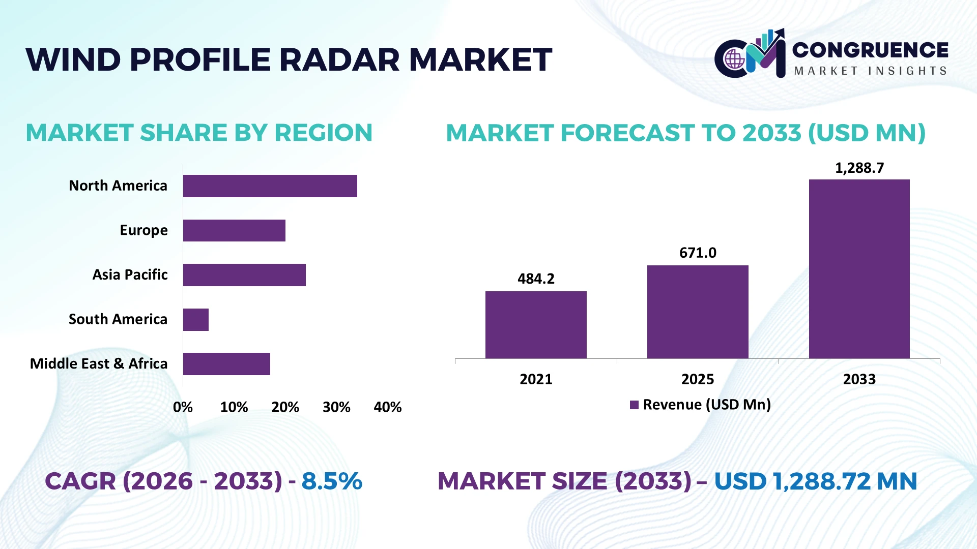
The Global Wind Profile Radar Market was valued at USD 671 Million in 2025 and is anticipated to reach a value of USD 1288.72 Million by 2033 expanding at a CAGR of 8.5% between 2026 and 2033. Growth is driven by expansion of high-resolution upper-air observation networks, numerical-weather-prediction assimilation, aviation wind-shear monitoring, wind-energy forecasting, and government deployment of automated Doppler profiling infrastructure.
China is the dominant deployment-scale country, with its national radar wind-profiler network reaching 128 stations, versus Japan’s 33-site WINDAS network; China therefore represents about 80% of their combined installed base. Japan records profiles every 10 minutes at 300-meter altitude intervals and up to 12 km. India is simultaneously procuring 19 wind-profiler systems under Mission Mausam, intensifying Asian weather-infrastructure investment. India’s ₹2,000-crore Mission Mausam and wider geopolitical focus on climate resilience and disaster preparedness reinforce procurement opportunities for suppliers combining reliable hardware, automated quality control, AI-enabled processing, and integration with national forecasting systems.
Strategically, vendors should prioritize scalable national observation programs where profiler hardware, data assimilation, maintenance, and high-resolution forecasting infrastructure are increasingly procured as integrated systems.
Market Size & Growth: USD 671 million in 2025 reaches USD 1,288.72 million by 2033 at 8.5%, driven by automated upper-air observation and weather-model modernization.
Top Growth Drivers: China’s 128-site network, Japan’s 33 profilers, and India’s planned 19 systems demonstrate expanding government-led atmospheric monitoring deployment.
Short-Term Forecast: By 2026, India targets roughly 50% improvement in forecast accuracy system-wide through denser observations, higher-resolution modeling, AI/ML, and advanced weather surveillance.
Emerging Technologies: AI/ML analytics, phased-array architectures, multi-frequency Doppler sensing, and automated quality-control algorithms are increasing profiler-data usability within real-time numerical forecasting workflows.
Regional Leaders: An indicative 2033 allocation places North America near USD 464 million, Asia-Pacific around USD 387 million, and Europe near USD 284 million, reflecting advanced observation-network deployment.
End-User Trends: Government meteorology remains deployment-intensive; NOAA’s cooperative system receives data from approximately 100 profiler sites operated by more than 35 agencies worldwide.
Pilot/Case Example: India’s 2025 procurement initiated acquisition of 10 wind-profiler systems, establishing a defined national deployment package under Mission Mausam.
Competitive Landscape: Vaisala is estimated near 18% share, competing with EEC, Beijing Metstar Radar, Nanjing Movelaser, and Chinese atmospheric-sensing specialists on range and integration.
Regulatory & ESG Impact: Japan’s 33-site network delivers 24-hour upper-air monitoring, improving severe-weather observation without recurring radiosonde launches at equivalent temporal frequency.
Investment & Funding: India allocated ₹2,000 crore to Mission Mausam during 2024–2026, including next-generation radars, wind profilers, advanced sensors, HPC, and forecasting infrastructure.
Innovation & Future Outlook: India plans 19 profilers alongside 25 microwave radiometers and 60 GPS radiosonde stations, signaling integrated multi-sensor atmospheric observation as the next deployment model.
Wind profile radar demand is concentrating around national meteorological networks, aviation safety, severe-weather nowcasting, wind-energy operations, and atmospheric research. Japan already operates 33 profilers providing observations every 10 minutes, while India is expanding deployment through Mission Mausam. AI-assisted data assimilation and integrated multi-sensor networks are now shifting procurement from standalone radar hardware toward complete atmospheric intelligence platforms, setting up the strategic discussion.
Wind profile radar is becoming strategic infrastructure as governments shift from periodic upper-air observations toward continuous, automated atmospheric sensing for severe-weather forecasting, aviation, defense, and renewable-energy operations. China operates 128 profiler stations, Japan maintains 33, and India is adding 19 systems under Mission Mausam. This infrastructure modernization is shifting competition from standalone radar supply toward integrated sensing, processing, and forecasting platforms.
Modern profilers generate observations every 10 minutes at Japan’s WINDAS sites, versus conventional radiosondes typically launched twice daily, delivering roughly 72 times greater temporal sampling. China leads in network scale, Japan in dense operational integration, while India is accelerating new deployment. By 2028, AI-assisted quality control, phased-array architectures, multi-sensor fusion, and automated data assimilation will become increasingly important procurement specifications as meteorological agencies pursue faster severe-weather detection.
India provides a practical deployment signal: Mission Mausam combines 19 wind profilers with 25 microwave radiometers and 60 GPS radiosonde stations. Suppliers are consequently investing in software-defined processing, remote diagnostics, local maintenance partnerships, and interoperable observation platforms. Competitive positioning will increasingly depend on converting continuous atmospheric measurements into reliable, forecast-ready data rather than simply delivering radar hardware.
National weather agencies are replacing observation gaps with continuously operating wind-profiler networks as extreme-weather forecasting becomes operationally critical. Japan’s 33-station WINDAS network produces observations every 10 minutes, while China operates approximately 128 stations and India plans 19 profilers under Mission Mausam. Compared with twice-daily radiosonde launches, 10-minute profiling provides roughly 72 times more temporal observations, materially improving visibility into rapidly evolving wind fields. India’s weather modernization program targets approximately 50% improvement in forecast accuracy through denser sensing, advanced modeling, and AI integration. This transition pushes radar vendors beyond hardware toward automated quality control, data assimilation, remote diagnostics, and lifecycle support. Suppliers are expanding local service partnerships and software capabilities because network availability and data continuity increasingly determine procurement competitiveness.
Wind profilers remain infrastructure-intensive compared with individual weather stations because deployment requires radio-frequency coordination, reliable power, communications, calibration, secure data links, and specialist maintenance. Japan operates only 33 WINDAS sites despite nationwide meteorological coverage, illustrating the selective placement required for expensive upper-air infrastructure. India’s modernization plan combines just 19 profilers with 25 microwave radiometers and 60 GPS radiosonde stations, confirming that agencies use mixed observation architectures rather than profiler-only networks. Radio-frequency interference can also degrade Doppler measurements and increase filtering requirements, particularly around dense telecommunications infrastructure. These constraints slow network scalability and raise lifecycle service costs. Vendors are responding with modular systems, remote monitoring, automated interference rejection, standardized interfaces, and local maintenance partnerships. The decisive procurement issue is therefore total network availability, not nominal radar performance alone.
The strongest opportunity lies in converting wind profilers from isolated sensors into nodes within AI-enabled atmospheric intelligence systems. India’s Mission Mausam architecture combines 19 profilers, 25 microwave radiometers, and 60 GPS radiosonde stations, creating a clear market for sensor fusion, automated quality control, and high-resolution data assimilation. Japan’s 10-minute profiler observations demonstrate the data density available for machine-learning nowcasting, while China’s 128-station footprint provides network scale for algorithm optimization. Through 2028, software-defined signal processing, adaptive clutter suppression, edge analytics, and digital twins can reduce manual data-validation workloads by an estimated 20–30% in highly automated environments. Vendors are increasing R&D around analytics and interoperability while partnering with meteorological agencies and research institutes. The non-obvious opportunity is recurring software and lifecycle services layered onto installed radar infrastructure.
Long-term deployment depends on maintaining comparable data quality across geographically dispersed profilers exposed to precipitation, ground clutter, electromagnetic interference, and changing atmospheric conditions. Japan’s network produces profiles every 10 minutes at roughly 300-meter vertical intervals, creating approximately 72 observation cycles daily per station and substantial continuous data-processing requirements. Scaling that operating model across China’s 128-site network illustrates the software, telecommunications, and technical-workforce burden behind national coverage. Cybersecurity also becomes more important as radar feeds connect directly with centralized forecasting and aviation systems. Agencies cannot tolerate inconsistent calibration or prolonged communication outages because degraded observations propagate into downstream models. Vendors must therefore invest in automated quality assurance, cybersecurity, remote calibration, redundant communications, and technician training. Sustainable competitive advantage rests on delivering uniform, forecast-ready observations across entire networks rather than maximizing individual sensor specifications.
Networks Shift Toward Dense Sampling: National agencies are moving from sparse upper-air observations toward continuous profiler networks. Japan operates 33 WINDAS sites generating profiles every 10 minutes at 300-meter intervals, while India is commissioning 10 wind profilers. Vendors are scaling automated quality-control, remote diagnostics, and centralized data ingestion to improve observation frequency and reduce manual intervention.
Multi-Sensor Architectures Gain Ground: Wind profilers are increasingly deployed alongside Doppler weather radar, microwave radiometers, radiosondes, and disdrometers rather than as standalone infrastructure. India’s Mission Mausam includes 10 profilers, 25 microwave radiometers, and 60 radiosonde stations. Suppliers are therefore prioritizing interoperable interfaces, synchronized processing, and common visualization platforms, improving forecast workflows and raising software integration value.
Boundary-Layer Monitoring Becomes Specialized: Operational users are expanding lower-atmosphere monitoring for airports, pollution studies, severe-weather analysis, and wind-energy operations. Cooperative profiler networks incorporate approximately 100 sites from more than 35 agencies, with 915 MHz systems dominant and some generating profiles every 10 minutes. Manufacturers are adapting compact UHF platforms and portable configurations for application-specific deployments.
Hardware Procurement Shifts Toward Services: Buyers increasingly evaluate calibration, uptime, cybersecurity, processing software, and lifecycle maintenance alongside transmitter specifications. Japan’s profilers operate continuously across 33 locations and observe winds up to approximately 12 km under favorable conditions. This operating model is pushing vendors toward remote monitoring, preventive maintenance, local service partnerships, and software upgrades that extend equipment availability.
Doppler Radar represents the leading type, with an estimated 42–45% share of the specified Wind Profile Radar Market. Its dominance stems from direct measurement of atmospheric radial velocity, mature signal-processing architecture, proven integration with national meteorological systems, and effective continuous profiling. Fixed Radar follows at approximately 21–23%, supported by permanent forecasting, aviation, and research installations requiring continuous availability. Sodar-Radar Systems account for an estimated 12–14%, combining complementary acoustic and electromagnetic observations where boundary-layer characterization is operationally valuable.
Portable Radar is the fastest-growing type, currently representing roughly 8–10% of the mix, as research institutes, wind developers, defense users, and temporary field campaigns seek relocatable atmospheric sensing. Scanning Radar holds approximately 11–13%, benefiting from applications requiring broader spatial coverage rather than primarily vertical profiling. Suppliers are responding with lighter antennas, software-defined receivers, remote configuration, and modular power systems. Investment is consequently shifting toward flexible platforms that preserve Doppler measurement accuracy while reducing deployment complexity and enabling multi-location utilization.
Meteorological Monitoring leads the application mix with an estimated 34–37% share, reflecting deployment by national weather agencies for upper-air observation, severe-weather forecasting, numerical model initialization, and continuous atmospheric surveillance. Wind Resource Assessment follows at roughly 20–22%, where vertical wind profiles reduce uncertainty before project development. Wind Farm Operations represent approximately 16–18%, supported by increasing use of atmospheric measurements for operating decisions, wake analysis, and short-term optimization.
Power Forecasting is the fastest-growing application, estimated at 14–16%, as higher renewable penetration increases the operational value of accurate wind-field observations for dispatch and grid balancing. Turbine Siting accounts for around 10–12%, remaining important during pre-construction analysis but requiring less continuous deployment once projects mature. Equipment providers are integrating automated data feeds, cloud analytics, forecasting APIs, and multi-sensor processing to move beyond measurement hardware. The strategic shift favors systems that convert vertical wind observations directly into model-ready inputs, strengthening recurring software and data-service opportunities alongside physical radar deployments.
Meteorological Agencies represent the largest end-user group, with an estimated 38–41% share, because national observation networks require permanent infrastructure, continuous operation, centralized processing, and long lifecycle support. Research Institutes account for approximately 18–20%, using profilers for boundary-layer studies, atmospheric physics, field experiments, and model validation. Wind Farm Developers hold an estimated 15–17%, primarily deploying profiling technologies during resource assessment, micrositing, and project-development phases.
Energy Operators are the fastest-growing end-user segment, estimated near 13–15%, as wind fleets become larger and power forecasting, wake management, and operating optimization gain commercial importance. Utilities represent approximately 11–13%, with adoption concentrated around renewable integration, grid forecasting, and weather-risk management. Suppliers are tailoring products through portable configurations for developers, continuous remote monitoring for agencies, and API-based analytics for energy operators. Competitive positioning increasingly requires distinct service models because government customers prioritize availability and calibration, while commercial energy users prioritize actionable forecasting and rapid deployment.
North America accounted for the largest market share at 36% in 2025 however, Asia-Pacific is expected to register the fastest growth, expanding at a CAGR of 10.1% between 2026 and 2033.

Integrated Atmospheric Networks Drive Deployment
North America accounts for approximately 36% of global demand, anchored by U.S. meteorological research, aviation, severe-weather monitoring, defense, launch operations, and renewable-energy assessment. NOAA’s Cooperative Agency Profilers infrastructure aggregates near-real-time measurements from approximately 100 sites operated by more than 35 agencies worldwide, with 915 MHz boundary-layer profilers forming the largest technology group. U.S. research infrastructure also supports 449 MHz and 1,290 MHz systems for higher-altitude and specialized observations. Operational priorities are shifting toward multi-sensor platforms combining radar profilers, microwave radiometers, ceilometers, disdrometers, and surface meteorology. Suppliers are responding with modular radar architectures, automated quality control, remote monitoring, and integrated software. The regional advantage lies in converting profiler measurements into model-ready datasets for forecasting and operational decision support rather than expanding hardware density alone.
United States Market Outlook: The United States leads through NOAA, NCAR, universities, defense facilities, airports, and commercial atmospheric-observation programs. NCAR’s profiling systems can measure vertical velocity every 1–2 minutes, while its advanced Multiple Antenna Profiler architecture achieves wind measurements within 30 seconds to 5 minutes. This research-to-deployment ecosystem strengthens domestic demand for rapid-processing radar, mobile systems, RASS integration, and advanced clutter-removal algorithms.
Centralized Processing Reshapes Observation Networks
Europe represents approximately 23% of global demand, with deployment increasingly coordinated through cross-border meteorological infrastructure rather than isolated national installations. EUMETNET’s E-PROFILE wind network incorporates about 30 radar wind profilers alongside approximately 100 weather radars supplying vertical wind profiles. Depending on frequency, these systems cover the atmospheric boundary layer to roughly 3 km, the troposphere to around 12 km, or atmospheric layers approaching 20 km. Centralized processing through the European Weather Cloud is strengthening real-time quality monitoring and data assimilation, while Doppler lidar is being incorporated alongside radar. This creates a hybrid sensing architecture rather than direct technology substitution. Vendors are consequently emphasizing standardized data formats, cloud connectivity, interoperability, calibration, and lifecycle support. European procurement increasingly rewards systems capable of joining multinational observation and numerical-weather-prediction workflows.
Germany Market Outlook: Germany holds a strategic position through Deutscher Wetterdienst, atmospheric research infrastructure, and domestic instrumentation expertise. DWD-developed Doppler-lidar processing is used within E-PROFILE’s centralized architecture, while German suppliers such as Scintec and METEK maintain established remote-sensing portfolios. Scintec reports more than 500 wind-profiler installations globally, giving Germany substantial engineering, signal-processing, servicing, and export capability across radar and acoustic profiling technologies.
National Networks Accelerate Deployment Scale
Asia-Pacific represents approximately 29% of current global demand and has the strongest large-network expansion profile. China operates more than 200 radar wind profiler stations within its modern vertical meteorological observation system, alongside 120 L-band radiosonde sites, creating one of the world’s deepest profiler infrastructures. Japan’s 33-station WINDAS network provides automated observations every 10 minutes, while India’s Mission Mausam is adding wind profilers within a broader atmospheric-sensing modernization program. The regional model therefore spans mature national networks, accelerated greenfield deployment, and integration with numerical forecasting. Domestic Chinese radar engineering also increases price and supply-chain competition against Western instrumentation vendors. Manufacturers are responding with localized production, phased-array systems, automated interference suppression, and integrated meteorological software. Procurement scale increasingly favors suppliers capable of supporting distributed networks rather than individual installations.
China Market Outlook: China provides the region’s strongest deployment concentration, with more than 200 operational radar wind profiler stations reported within the China Meteorological Administration’s observation infrastructure by the end of 2023. Twenty-nine collocated profiler-radiosonde stations have also supported advanced turbulence research. Domestic manufacturing capability, large-area weather monitoring, aviation requirements, and severe-weather forecasting create a powerful platform for indigenous radar hardware and algorithm development.
Wind Expansion Broadens Measurement Requirements
South America represents approximately 5% of global demand, with Brazil providing the strongest commercial linkage between atmospheric profiling and expanding wind-power infrastructure. The region’s profiler installations remain less dense than networks in China, Europe, or the United States, increasing reliance on project-specific atmospheric measurement, research facilities, and conventional radiosondes. Brazil’s installed wind capacity has moved beyond 30 GW, raising the operational value of boundary-layer characterization, power forecasting, turbine siting, and extreme-weather monitoring. Complex coastal wind regimes create opportunities for portable profilers and hybrid radar-lidar measurement campaigns, although equipment imports, specialist maintenance availability, and remote-site communications constrain deployment consistency. Vendors are addressing these limitations through distributor partnerships, remote diagnostics, compact systems, and integrated wind-resource services. Commercial adoption is consequently tied more closely to energy-project economics than national profiler-network density.
Brazil Market Outlook: Brazil combines Latin America’s largest wind-generation base with extensive meteorological and energy-research capabilities, making it the primary regional target for advanced profiling technology. More than 1,000 operating wind farms create a substantial measurement ecosystem around resource characterization and forecasting. Suppliers that combine portable sensing, remote servicing, local technical partners, and bankable wind-data workflows hold the strongest positioning for utility-scale deployments.
Weather Resilience Drives Infrastructure Modernization
Middle East & Africa accounts for approximately 7% of global demand, with investment concentrated around aviation, extreme-weather monitoring, atmospheric research, renewable-energy development, and national forecasting modernization. Gulf countries require high-resolution boundary-layer measurements for airport operations, dust transport, convection monitoring, and emerging wind-energy assessment, while African deployments remain more geographically selective because of observation-network and maintenance constraints. Saudi Arabia is developing wind projects at multi-gigawatt scale, increasing requirements for bankable resource characterization and short-term power forecasting. Meanwhile, expanding Gulf meteorological infrastructure favors automated remote sensing capable of continuous operation under dust and high-temperature conditions. Suppliers are emphasizing ruggedized electronics, remote maintenance, multi-sensor integration, and local technical partnerships. The region’s strategic opportunity is concentrated in high-value infrastructure nodes rather than uniform national deployment.
Saudi Arabia Market Outlook: Saudi Arabia offers the strongest energy-linked deployment case as renewable procurement moves beyond solar into utility-scale wind. The 400 MW Dumat Al Jandal project established an operational reference point, while subsequent multi-gigawatt renewable programs increase requirements for wind-resource validation and forecasting. Desert operating conditions reward profilers with automated diagnostics, robust thermal management, low maintenance requirements, and reliable remote communications.
Scintec, Radiometrics, Beijing Metstar Radar, METEK, and Nanjing Movelaser compete across atmospheric profiling, while specialist radar suppliers face lidar and sodar alternatives in lower-atmosphere applications. The top five suppliers hold an estimated 48–52% combined share, reflecting specialized engineering and procurement qualification requirements. Scintec competes through installed-base depth and all-weather radar profiling; Radiometrics emphasizes integrated atmospheric systems; Chinese vendors challenge established suppliers through localization and pricing estimated 15–25% lower on selected configurations. Advanced digital processing can shorten measurement cycles by over 50% versus traditional 10–15-minute Doppler beam-swinging approaches, intensifying technology competition. Suppliers are expanding remote diagnostics, multi-sensor integration, local service partnerships, and software analytics. The competitive shift is from standalone transmitters toward forecast-ready atmospheric intelligence platforms. Frequency licensing, antenna engineering, signal-processing expertise, validation, and government procurement qualification create substantial entry barriers. Winning requires proven measurement accuracy, continuous uptime, interoperable data, localized lifecycle support, and competitive total ownership cost across meteorological networks.
Scintec AG
Radiometrics Corporation
Beijing Metstar Radar Co., Ltd.
METEK Meteorologische Messtechnik GmbH
Nanjing Movelaser Co., Ltd.
Beijing Institute of Radio Measurement
China Electronics Technology Group Corporation
DeTect, Inc.
EEC Corporation
Vaisala Oyj
Leonardo S.p.A.
Thales Group
Current systems rely on phased-array UHF/VHF radar, Doppler beam swinging, RASS, automated clutter filtering, and centralized quality control. Modern multi-antenna architectures can cut wind-measurement cycles from 10–15 minutes to 30 seconds–5 minutes, improving temporal resolution by roughly 67–97%. Adoption is strongest in national meteorological, aviation, and research networks, where continuous unattended operation strengthens forecast readiness and lowers manual observation dependence.
Emerging platforms integrate software-defined processing, AI-assisted spectral classification, edge analytics, cloud ingestion, and multi-sensor fusion with lidar, microwave radiometers, and weather radar. Unified preprocessing can remove multi-vendor data incompatibility, while automated quality-control workflows can reduce analyst intervention by 20–30% in mature deployments. Compared with legacy proprietary processing, standardized NetCDF workflows improve interoperability and accelerate assimilation into numerical models, benefiting agencies operating mixed fleets.
Disruptive development is moving toward adaptive phased arrays, digital twins, autonomous calibration, and forecast-ready atmospheric intelligence services. Portable profilers and compact scanning systems expand deployment into wind farms, airports, coastal testbeds, and temporary campaigns. Through 2026–2028, network operators will increasingly prioritize cybersecurity, remote diagnostics, and API-based data delivery. Suppliers combining reliable hardware with analytics and lifecycle support gain the strongest competitive advantage because procurement is shifting from isolated instruments toward integrated operational platforms at network scale.
February 2024 – Scintec introduced AWAIRE Aviation with LAP3000 radar wind profilers, enabling microburst detection up to 5 minutes earlier than LLWAS, scanning Doppler lidar, or TDWR. The technology increases warning lead time, strengthening airport operational safety during hazardous wind events. Source: scintec.com
August 2025 – India Meteorological Department opened procurement for 10 wind profiler systems under Mission Mausam, formalizing national deployment. The tender expands high-frequency upper-air observation and creates demand for integrated radar hardware, processing, installation, maintenance, and technical support capabilities nationwide. Source: imd.gov.in
May 2026 – Delhi International Airport inaugurated SkyCast, integrating radar wind profiling with SODAR, microwave radiometry, aerosol sensing, and lidar to monitor atmosphere up to 3 km. The deployment strengthens real-time fog, turbulence, and aviation hazard decision-support capability. Source: moneycontrol.com
April 2026 – Korea Meteorological Administration researchers standardized wind-profiler data from four manufacturers and six models into unified NetCDF processing. The framework removes incompatible raw-data barriers, enabling consistent cross-station analytics, turbulence retrieval, and numerical-weather-prediction integration across heterogeneous operational radar fleets. Source: nature.com
The report assesses Doppler Radar, Sodar-Radar Systems, Scanning Radar, Fixed Radar, and Portable Radar across Wind Resource Assessment, Wind Farm Operations, Turbine Siting, Power Forecasting, and Meteorological Monitoring. End-user coverage includes Wind Farm Developers, Utilities, Energy Operators, Research Institutes, and Meteorological Agencies, with analysis spanning North America, Europe, Asia-Pacific, South America, and Middle East & Africa.
Technology coverage includes phased-array UHF/VHF systems, RASS, software-defined processing, automated quality control, AI-enabled spectral analysis, multi-sensor fusion, and portable atmospheric profiling. National deployment benchmarks include Japan’s 33-site WINDAS infrastructure, India’s planned 19-system expansion, and large-scale Chinese profiler networks. The report evaluates procurement patterns, interoperability, aviation deployment, renewable-energy applications, localization, and lifecycle services, supporting investment planning, geographic expansion, competitive positioning, partnership decisions, and technology-roadmap development through 2026–2033.
| Report Attribute/Metric | Report Details |
|---|---|
Market Revenue in 2025 | USD 671 Million |
Market Revenue in 2033 | USD 1288.72 Million |
CAGR (2026 - 2033) | 8.5% |
Base Year | 2025 |
Forecast Period | 2026 - 2033 |
Historic Period | 2021 - 2025 |
Segments Covered | By Type
By Application
By End-User
|
Key Report Deliverable | Revenue Forecast, Growth Trends, Market Dynamics, Segmental Overview, Regional and Country-wise Analysis, Competition Landscape |
Region Covered | North America, Europe, Asia-Pacific, South America, Middle East, Africa |
Key Players Analyzed | Scintec AG, Radiometrics Corporation, Beijing Metstar Radar Co., Ltd., METEK Meteorologische Messtechnik GmbH, Nanjing Movelaser Co., Ltd., Beijing Institute of Radio Measurement, China Electronics Technology Group Corporation, DeTect, Inc., EEC Corporation, Vaisala Oyj, Leonardo S.p.A., Thales Group |
Customization & Pricing | Available on Request (10% Customization is Free) |