
Reports
The Global Professional Map Services Market was valued at USD 16,126.5 Million in 2025 and is anticipated to reach a value of USD 39,644.3 Million by 2033 expanding at a CAGR of 11.9% between 2026 and 2033. Growth is being driven by infrastructure digitization, high-definition mapping for autonomous mobility, LiDAR and UAV deployment, digital-twin programs, and rising requirements for authoritative geospatial data.
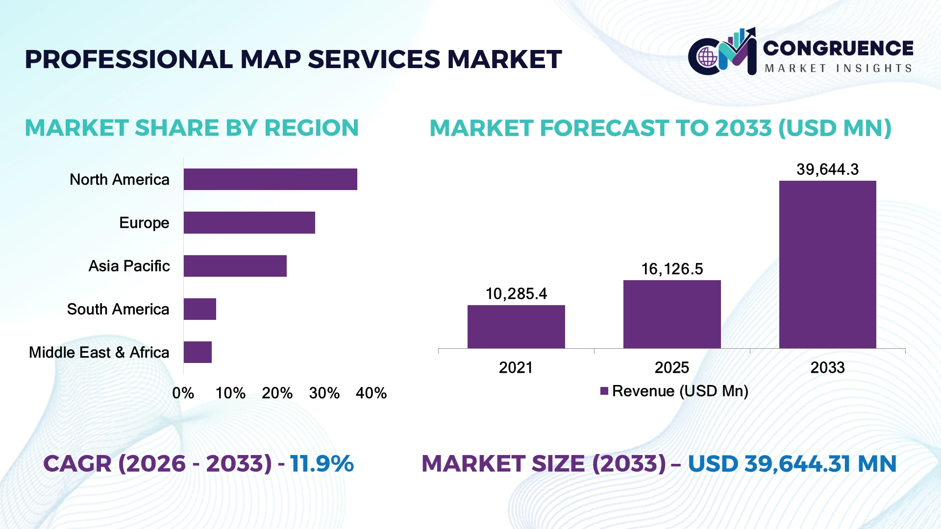
The United States accounts for approximately 37% of global professional map services activity, supported by federal geospatial programs, transportation modernization, utilities, defense, and autonomous-vehicle mapping. China follows at roughly 15%, driven by smart-city and infrastructure programs, while India is accelerating digital cadastral and national geospatial initiatives. U.S. professional mapping projects increasingly require centimeter-level positioning, compared with meter-level requirements in conventional mapping workflows.
Strategically, providers should prioritize high-accuracy, AI-enabled mapping and sector-specific geospatial intelligence rather than competing solely on conventional cartographic production.
Market Size & Growth: USD 16,126.5 Million in 2025 to USD 39,644.3 Million by 2033 at 11.9% CAGR, driven by LiDAR, digital twins and infrastructure mapping.
Top Growth Drivers: AI mapping 35%, LiDAR adoption 30%, digital-twin deployment 28%.
Short-Term Forecast: By 2028, AI-assisted processing can reduce repetitive mapping workloads by 25–40%.
Emerging Technologies: AI feature extraction, LiDAR, UAV photogrammetry and 3D geospatial modeling are reshaping workflows.
Regional Leaders: North America USD 14.6 Billion, Asia-Pacific USD 11.9 Billion, Europe USD 7.9 Billion by 2033.
Consumer/End-User Trends: Infrastructure and utilities represent over 40% of professional mapping workloads.
Pilot/Case Example: 2025 USGS automation trials digitized 100+ geological maps with AI-assisted extraction and georeferencing.
Competitive Landscape: Esri leads with approximately 18%; Hexagon, Trimble, HERE and Fugro remain major competitors.
Regulatory & ESG Impact: Digital cadastral and environmental mapping programs are expanding authoritative geospatial datasets by 15%+ annually.
Investment & Funding: Private earth-intelligence funding reached approximately USD 3.2 Billion in 2025, accelerating commercial geospatial-data capacity.
Innovation & Future Outlook: 2026–2028 investment is shifting toward real-time mapping, AI validation, digital twins and autonomous-navigation datasets.
Professional Map Services are increasingly concentrated around transportation, utilities, construction, mining, defense, environmental monitoring, cadastral modernization, and autonomous mobility. Approximately 40% of workloads are linked to infrastructure-intensive applications, while AI-assisted feature extraction and LiDAR processing are reducing manual GIS workloads. India’s National Geospatial Mission and expanding CORS infrastructure are strengthening demand for high-resolution, interoperable mapping, creating a transition toward continuously updated spatial datasets and analytics-led services.
Professional map services are becoming strategic infrastructure because governments and enterprises increasingly require authoritative location intelligence for infrastructure investment, asset management, autonomous mobility, environmental compliance, and digital-twin development. The market is shifting from periodic map production toward continuously updated geospatial datasets that integrate GNSS, LiDAR, UAV imagery, satellite data, GIS and cloud analytics. India’s geospatial modernization programs and the U.S. emphasis on infrastructure and geological mapping illustrate this transition.
AI-assisted mapping is materially changing production economics. Automated feature extraction and georeferencing can reduce repetitive processing workloads by approximately 25–40% compared with fully manual workflows, while LiDAR delivers centimeter-level spatial detail required for engineering and autonomous-navigation applications. North America remains strongest in high-value engineering, defense and autonomous-mobility mapping, whereas Asia-Pacific is expanding through infrastructure, cadastral modernization and smart-city programs.
During 2026–2028, professional map providers will increasingly combine field acquisition with AI processing, 3D modeling and cloud-based delivery. A transportation project, for example, can combine mobile LiDAR, drone imagery and GIS into a single asset database instead of maintaining disconnected survey outputs. Providers are therefore increasing investment in AI validation, sensor integration, cloud platforms and specialist partnerships. Competitive advantage will increasingly depend on accuracy, update frequency, interoperability and the ability to convert spatial data into operational decisions.
AI-driven automation is accelerating professional map production as providers process larger LiDAR, imagery, and point-cloud datasets without proportionally expanding field and GIS teams. In the 2025 Trimble Geospatial industry survey, 42% of respondents identified AI and machine learning as the technologies expected to have the greatest industry impact, while 44% planned to increase 3D laser scanning. This shift is reducing repetitive feature extraction and accelerating quality-control workflows. In India, expanding CORS infrastructure and national geospatial programs are strengthening demand for high-accuracy mapping. Providers are responding through AI-assisted classification, automated drafting, cloud processing, and sensor partnerships. The strategic advantage is shifting from field capacity alone toward the ability to convert high-volume spatial data into validated deliverables faster.
Professional map services remain constrained by specialist labor shortages, complex datasets, and inconsistent interoperability across GIS, CAD, LiDAR, GNSS, and cloud environments. Approximately 69% of geospatial professionals surveyed in 2025 reported difficulty finding qualified workers, including 27% describing the shortage as very difficult. At the same time, projects increasingly generate millions of spatial observations rather than conventional survey-scale datasets, raising processing and quality-assurance requirements. U.S. engineering firms face additional pressure from project-specific accuracy and certification requirements, while emerging markets often lack sufficient high-end processing capacity. Providers are mitigating these constraints through workflow automation, standardized data schemas, remote processing teams, and technician training. The operational priority is to reduce dependence on scarce specialists without compromising survey-grade accuracy.
The next opportunity lies in combining LiDAR, AI, cloud processing, and digital twins to deliver continuously updated spatial intelligence rather than one-time maps. Approximately 44% of geospatial professionals surveyed in 2025 planned to increase 3D laser-scanning activity, while 42% expected AI and machine learning to have the greatest industry impact. In the United States, infrastructure, utilities, autonomous mobility, and environmental monitoring are creating demand for higher-frequency mapping. India offers another high-potential pathway through CORS expansion, UAV adoption, and national geospatial modernization. Providers are investing in mobile mapping, SLAM, AI feature extraction, and Mapping-as-a-Service models. A non-obvious opportunity is recurring asset monitoring: the same mapped corridor can generate subscription revenue through periodic change detection rather than a single project fee.
Scaling AI-assisted professional mapping creates a difficult balance between processing speed and survey-grade reliability. Around 69% of surveyed geospatial professionals already face qualified-worker shortages, while AI-generated outputs still require human validation for boundary interpretation, feature classification, and project-specific accuracy standards. Multimodal geospatial models also face challenges involving data heterogeneity, distribution shifts, interpretability, and privacy. These pressures are particularly important for cadastral, transportation, defense, and engineering projects where inaccurate spatial information creates contractual or regulatory exposure. Companies must therefore invest in automated quality-control layers, provenance tracking, standardized metadata, cybersecurity, and specialist review teams. The long-term competitive differentiator will not be maximum automation; it will be controlled automation that delivers faster mapping while maintaining defensible accuracy and traceability.
AI Enters Production Workflows: AI and machine learning are moving beyond experimentation into feature extraction, classification, change detection, and quality control. In 2025, 42% of surveyed geospatial professionals identified AI/ML as the technology expected to have the greatest industry impact. Providers are embedding automated interpretation into GIS pipelines to reduce repetitive processing and redirect skilled staff toward validation and analysis.
3D Scanning Gains Priority: Demand is shifting toward dense three-dimensional reality capture, with 44% of surveyed professionals planning to increase 3D laser-scanning activity. Modern systems can capture millions of points in seconds rather than roughly thousands through older workflows. Engineering, construction, utilities, and industrial operators are therefore adopting terrestrial scanning, SLAM, and mobile mapping to accelerate site documentation and improve spatial detail.
Cloud Mapping Becomes Continuous: Mapping workflows are increasingly moving from project-specific file delivery toward cloud-connected processing and collaborative spatial databases. Providers are combining LiDAR, UAV imagery, GNSS and GIS layers so updates can move through shared environments rather than disconnected desktop workflows. The shift reduces handoffs and supports faster change detection, while subscription-based delivery models create recurring demand for infrastructure and asset monitoring.
India Expands Geospatial Infrastructure: India's National Geospatial Mission is emphasizing CORS infrastructure, high-resolution mapping, AI, LiDAR, UAVs and digital twins. This is shifting professional map services toward standardized, interoperable spatial datasets for infrastructure and governance. Providers are responding through local technology partnerships and expanded acquisition capacity, while the combination of national infrastructure and private-sector mapping creates opportunities for recurring asset-monitoring services.
Digital mapping services represent the leading type, accounting for approximately 42% of global professional map services demand, supported by broad compatibility with GIS platforms, relatively lower acquisition costs, and established use across transportation, utilities, government, and commercial planning. 3D mapping is the fastest-growing type, capturing roughly 28% of demand as LiDAR, photogrammetry, mobile mapping, and digital-twin projects move from specialist applications into mainstream infrastructure workflows. Traditional 2D mapping remains strategically relevant at approximately 30%, particularly for cadastral records, utility inventories, and regulatory documentation.
The investment mix is shifting toward 3D capabilities, with approximately 44% of surveyed geospatial professionals planning to increase 3D laser-scanning activity. Providers are expanding sensor fleets, AI-based point-cloud processing, and cloud delivery to increase project throughput. The business implication is clear: 2D remains the volume foundation, while 3D offers higher-value engineering and asset-management contracts, encouraging companies to prioritize integrated 2D/3D production rather than replace legacy mapping entirely.
A 2025 Trimble Geospatial industry survey found that 44% of respondents planned to increase 3D laser-scanning activity, reinforcing the shift toward higher-density spatial data acquisition.
Infrastructure and transportation mapping account for approximately 34% of professional map services demand, supported by road, rail, utility, and urban-development projects requiring accurate spatial databases and asset inventories. Construction and engineering represent around 26% and are the fastest-growing application as contractors increasingly use LiDAR, UAV photogrammetry, and 3D models for site measurement and progress verification. Government and cadastral mapping remain mature applications, while environmental monitoring and autonomous-mobility mapping are emerging higher-value niches.
Construction-related mapping workflows are increasingly adopting digital deliverables, with approximately 40% of larger projects incorporating some form of 3D reality capture or model-based spatial information. Providers are responding with mobile mapping, drone acquisition, automated feature extraction, and cloud collaboration. The strategic shift is from delivering static maps toward continuously updated project intelligence, allowing providers to capture recurring monitoring contracts. Companies with integrated survey, GIS, 3D modeling, and analytics capabilities are better positioned to win complex infrastructure programs.
A 2025 industry survey reported that 42% of geospatial professionals expected AI and machine learning to have the greatest impact on the sector, strengthening demand for automated mapping workflows across infrastructure and engineering applications.
Government agencies represent approximately 31% of professional map services demand, reflecting cadastral modernization, national mapping, defense, environmental monitoring, and infrastructure planning requirements. Engineering and construction companies account for about 27% and represent the fastest-growing end-user group as project owners demand survey-grade spatial data, 3D site models, and progress monitoring. Utilities and transportation operators together contribute approximately 24%, driven by network inventories, corridor mapping, asset inspection, and maintenance planning.
Government procurement remains relatively standardized and project-driven, whereas engineering firms increasingly prefer integrated, repeatable mapping workflows that connect field capture directly with CAD, BIM, GIS, and digital-twin environments. Around 44% of geospatial professionals plan to increase 3D laser-scanning activity, encouraging suppliers to target construction and infrastructure enterprises with bundled acquisition and processing services. Providers are expanding through equipment partnerships, specialist GIS teams, subscription-based monitoring, and multi-year framework contracts. The strongest commercial opportunity is shifting toward enterprise buyers requiring continuous spatial intelligence rather than one-time map production.
The 2025 U.S. Bureau of Labor Statistics outlook places surveying and mapping technician employment within a substantial technical workforce, reinforcing the importance of automation and specialist capacity as professional geospatial projects become more data-intensive.
North America accounted for the largest market share at 37% in 2025 however, Asia-Pacific is expected to register the fastest growth, expanding at a CAGR of 12.8% between 2026 and 2033.
High-Precision Mapping Moves Into Infrastructure Intelligence
North America contributes approximately 37% of global professional map services demand, supported by transportation modernization, utilities, defense, construction, autonomous mobility, and large-scale infrastructure programs. The United States accounts for nearly 82% of regional activity, with demand concentrated around high-accuracy surveying, LiDAR acquisition, digital twins, and geospatial asset management. More than 45% of major infrastructure mapping projects increasingly incorporate 3D data capture or automated spatial processing. Engineering firms are expanding mobile mapping fleets and cloud-based GIS workflows to shorten field-to-delivery cycles. The region's mature surveying ecosystem also supports premium pricing for centimeter-level datasets. Providers are therefore shifting investment toward AI-assisted point-cloud classification, continuous asset monitoring, and integrated GIS platforms rather than conventional map-production capacity.
United States Market Outlook: The United States remains the leading national market because of its extensive transportation network, defense requirements, utility infrastructure, and autonomous-vehicle development. Federal and state infrastructure programs continue generating demand for corridor mapping, asset inventories, terrain models, and environmental datasets. More than 40% of large U.S. geospatial projects increasingly incorporate LiDAR, mobile mapping, or 3D modeling, creating strong opportunities for providers that combine field acquisition with automated processing and cloud delivery.
Regulatory Mapping and Digital Twins Reshape Spatial Workflows
Europe represents approximately 28% of global professional map services demand, with Germany, the United Kingdom, France, and the Netherlands serving as major commercial centers. Infrastructure modernization, cadastral digitization, environmental monitoring, and smart-city programs are increasing demand for authoritative spatial datasets. Germany accounts for roughly 25% of European demand, supported by automotive manufacturing, engineering, utilities, and industrial asset mapping. Approximately 40% of major engineering workflows increasingly incorporate 3D surveying or digital-twin elements. Providers are combining terrestrial LiDAR, UAV photogrammetry, GNSS, and cloud GIS to improve survey consistency and reduce repeated site visits. The strategic shift is toward continuously updated infrastructure models that support both construction planning and lifecycle asset management.
Germany Market Outlook: Germany is the region's most strategically important country because of its industrial engineering base, automotive manufacturing clusters, rail infrastructure, and technically mature surveying ecosystem. Stuttgart, Munich, Frankfurt, and Berlin generate significant demand for high-resolution mapping across manufacturing, transport, construction, and urban planning. Approximately 40% of large engineering projects increasingly use 3D reality-capture workflows, strengthening opportunities for LiDAR specialists and integrated geospatial service providers.
Infrastructure Scale Accelerates AI and 3D Mapping Adoption
Asia-Pacific represents approximately 24% of global professional map services demand and is expanding rapidly through infrastructure construction, smart-city programs, cadastral modernization, mining, utilities, and autonomous mobility. China accounts for approximately 38% of regional demand, while India is rapidly increasing its contribution through national geospatial programs and CORS infrastructure. More than 45% of new large infrastructure projects increasingly incorporate digital surveying, UAV mapping, LiDAR, or GIS-based asset management. China benefits from domestic sensor and mapping technology capabilities, while India offers significant demand from roads, railways, utilities, urban development, and land-record modernization. Providers are expanding local processing centers, UAV fleets, AI classification capabilities, and partnerships with engineering firms to handle growing project volumes.
China Market Outlook: China remains the largest national market in Asia-Pacific, supported by extensive transportation construction, urban redevelopment, industrial parks, mining, utilities, and smart-city deployment. Major infrastructure programs increasingly require high-resolution terrain and asset datasets, while domestic technology capabilities strengthen local supply of mapping sensors and processing platforms. Approximately 40% of large-scale engineering programs increasingly incorporate 3D spatial information, creating sustained demand for LiDAR, photogrammetry, and digital-twin services.
Infrastructure and Mining Projects Expand High-Value Mapping
South America contributes approximately 7% of global professional map services demand, with Brazil representing more than 55% of regional activity. Mining, transportation, agriculture, utilities, environmental monitoring, and construction are the principal demand centers. Brazil's large mining and infrastructure projects increasingly require UAV surveys, LiDAR terrain models, cadastral mapping, and environmental datasets, while Argentina, Chile, and Colombia are expanding specialized applications. Around 30% of large mining and infrastructure projects increasingly incorporate digital or 3D mapping workflows. High equipment costs and uneven geospatial infrastructure remain constraints outside major industrial hubs. Providers are responding through regional survey partnerships, shared sensor fleets, cloud processing, and project-based equipment deployment. Mobile mapping offers a particularly strong advantage where extensive field coverage must be achieved with limited local technical capacity.
Brazil Market Outlook: Brazil is the leading South American market because of its extensive mining, agriculture, logistics, utilities, and infrastructure footprint. São Paulo, Minas Gerais, and Paraná are important commercial and industrial centers for professional mapping activity. More than half of regional demand is concentrated in Brazil, while mining operators increasingly use LiDAR, UAV photogrammetry, and 3D terrain models for site planning, volumetric measurement, environmental compliance, and asset monitoring.
Mega-Projects Create Demand for Continuous Spatial Intelligence
Middle East & Africa represents approximately 6% of global professional map services demand, with the United Arab Emirates, Saudi Arabia, and South Africa accounting for the largest deployment concentration. Large-scale urban developments, transportation corridors, energy infrastructure, mining, utilities, and smart-city programs are expanding requirements for high-resolution spatial datasets. The UAE and Saudi Arabia together account for approximately 55% of regional demand, while more than 35% of major new development projects increasingly integrate 3D mapping or digital-twin capabilities. Suppliers are establishing local acquisition teams, technology partnerships, and cloud-processing capabilities to support project-scale requirements. The key commercial shift is from one-time surveying toward continuous geospatial monitoring throughout construction and infrastructure lifecycles.
Saudi Arabia Market Outlook: Saudi Arabia is the region's strongest strategic market because of large-scale urban, tourism, transportation, energy, and smart-city developments. Riyadh and Jeddah are major mapping-service centers, while projects associated with Vision 2030 require detailed terrain, infrastructure, environmental, and asset datasets. More than 35% of major development programs increasingly incorporate digital mapping or 3D spatial models, creating opportunities for providers offering integrated surveying, GIS, LiDAR, UAV, and digital-twin capabilities.
The market pits Esri, Hexagon and Trimble against HERE, Fugro and regional surveying specialists, with GIS-platform leaders competing against measurement, mapping-content and cost-focused providers. The top five players hold an estimated 31% combined share, leaving room for specialized firms. Competition centers on accuracy, automation, coverage, turnaround and integration; 42% of professionals identify AI as the highest-impact technology, while 44% plan to increase 3D laser scanning. Leaders are expanding sensor fleets, cloud platforms and geospatial content through acquisitions and partnerships. Hexagon’s aerial-mapping expansion and Esri’s AI collaborations illustrate a shift toward vertically integrated data-to-analytics ecosystems. Regional providers compete through localized field capacity and customized engineering deliverables. Entry pressure remains high around survey-grade equipment, authoritative datasets, specialist talent, certifications and enterprise software integration. The competitive shift favors providers that combine acquisition, processing and analytics. Winning requires scalable sensor infrastructure, defensible accuracy, rapid delivery, interoperable platforms, recurring data services and strong sector partnerships.
Esri
Hexagon AB
Trimble Inc.
HERE Technologies
Fugro
Bentley Systems
Topcon Positioning Systems
Leica Geosystems
TomTom
Garmin
Planet Labs
Maxar Technologies
Genesys International
Cyient
AI-assisted mapping is moving into production, with 42% of geospatial professionals identifying AI and machine learning as the technologies expected to have the greatest industry impact. GeoAI automates feature extraction, classification, change detection and metadata creation, reducing repetitive GIS workloads and accelerating delivery. Foundation models are emerging for imagery interpretation and natural-language spatial analysis. Providers combining AI with cloud GIS gain throughput advantages, while specialist firms reduce dependence on scarce technical staff.
Reality capture is becoming denser and faster. Forty-four percent of professionals plan to increase 3D laser scanning, while next-generation airborne LiDAR can deliver survey productivity than conventional systems. Fugro reports 39% faster point-cloud classification using its automated workflow. Mobile LiDAR, SLAM, UAV photogrammetry and LiDAR are moving into infrastructure and engineering projects. Compared with manual mapping, automated classification can shorten processing cycles and improve consistency.
From 2026 to 2028, competitive advantage will shift toward sensor-to-cloud platforms. AI validation, digital twins, real-time mapping and geospatial APIs will support updated asset intelligence. Esri and Hexagon benefit from software and content ecosystems, while Trimble benefits from field-to-office hardware connectivity. Companies investing now in interoperable data pipelines, automated quality control and recurring mapping services will capture infrastructure, mobility, utility and environmental contracts.
September 2025 Esri released GeoAI, documenting real-world AI-enhanced GIS applications across public and private sectors. The release formalized automation of spatial analysis and workflows, strengthening enterprise adoption of AI-assisted mapping and accelerating demand for software-led geospatial services globally. Source: esri.com
June 2025 Hexagon agreed to acquire APEI, adding an aerial-mapping aircraft fleet serving France, Europe and Africa. The acquisition strengthens large-scale imagery capacity and expands Hexagon’s geospatial content ecosystem, supporting faster delivery of high-resolution mapping products across markets. Source: hexagon.com
January 2025 Fugro expanded Florida Seafloor Mapping Initiative coverage to 42,000 square kilometres offshore, scaling from one survey vessel to a multivessel operation. The deployment increases coastal mapping capacity and supports infrastructure planning, resilience assessment and environmental management. Source: fugro.com
January 2025 HERE and AWS announced a 10-year, $1 billion cloud infrastructure agreement for AI-powered map and location services. The partnership expands mapping infrastructure for automotive, logistics and mobility customers, strengthening geospatial delivery and software-defined vehicle development. Source: here.com (Here)
The Professional Map Services Market Report evaluates digital mapping, 3D mapping, LiDAR, photogrammetry, mobile mapping, cadastral mapping, and specialized geospatial content services across infrastructure, transportation, construction, utilities, mining, defense, environmental monitoring, autonomous mobility, and government applications. Coverage spans government agencies, engineering and construction firms, utilities, transportation operators, technology companies, and other enterprise end users.
The report provides regional and country-level analysis across North America, Europe, Asia-Pacific, South America, and Middle East & Africa, with emphasis on the United States, China, India, Germany, Brazil, and Saudi Arabia. It assesses AI-assisted processing, digital twins, UAV mapping, GNSS, cloud GIS, real-time mapping, and emerging geospatial foundation models. Quantitative analysis of adoption, deployment concentration, technology mix, and competitive positioning supports investment screening, geographic expansion, partnership selection, service portfolio planning, and strategic positioning through 2026–2033.
| Report Attribute/Metric | Report Details |
|---|---|
|
Market Revenue in 2025 |
USD 16,126.5 Million |
|
Market Revenue in 2033 |
USD 39,644.3 Million |
|
CAGR (2026 - 2033) |
11.9% |
|
Base Year |
2025 |
|
Forecast Period |
2026 - 2033 |
|
Historic Period |
2021 - 2025 |
|
Segments Covered |
By Type
By Application
By End-User
|
|
Key Report Deliverable |
Revenue Forecast, Growth Trends, Market Dynamics, Segmental Overview, Regional and Country-wise Analysis, Competition Landscape |
|
Region Covered |
North America, Europe, Asia-Pacific, South America, Middle East, Africa |
|
Key Players Analyzed |
Esri, Hexagon AB, Trimble Inc., HERE Technologies, Fugro, Bentley Systems, Topcon Positioning Systems, Leica Geosystems, TomTom, Garmin, Planet Labs, Maxar Technologies, Genesys International, Cyient |
|
Customization & Pricing |
Available on Request (10% Customization is Free) |