
Reports
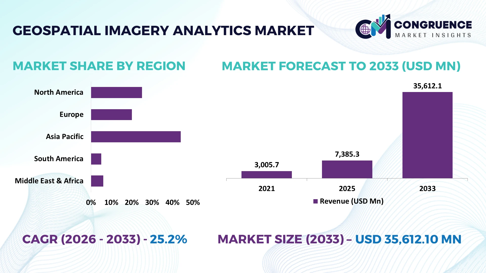
The Global Geospatial Imagery Analytics Market was valued at USD 7385.29 Million in 2025 and is anticipated to reach a value of USD 35612.1 Million by 2033 expanding at a CAGR of 25.2% between 2026 and 2033. Growth is driven by AI-powered satellite image interpretation, expanding Earth observation constellations, defense intelligence modernization, cloud-native geospatial processing, and automated infrastructure monitoring.
The United States dominates advanced geospatial imagery analytics through commercial satellite operators, defense intelligence agencies, and hyperscale cloud infrastructure. The National Reconnaissance Office's proliferated architecture includes contracts supporting hundreds of commercial imaging satellites, while Planet operates approximately 200 Earth observation satellites. Compared with Europe's Copernicus program, which provides open Sentinel imagery, American providers emphasize high-frequency commercial monitoring and defense integration. The National Geospatial-Intelligence Agency's GEOINT modernization initiatives further support AI-assisted imagery exploitation across defense, agriculture, energy, and infrastructure applications.
Strategically, geospatial analytics providers must prioritize automated image interpretation, sovereign data access, and scalable cloud processing to capture defense contracts and recurring enterprise monitoring workloads.
Market Size & Growth: USD 7,385.29 million in 2025, reaching USD 35,612.1 million by 2033 at 25.2% CAGR, driven by AI-enabled satellite intelligence.
Top Growth Drivers: Commercial imagery supports over 90% of NGA foundation mapping; 78.4% of direct Sentinel downloads originate in Europe; openEO handles over 75% of Copernicus Browser processing.
Short-Term Forecast: By 2028, cloud-native imagery processing targets 20% faster analytical turnaround through automated object detection and distributed computing; improvement remains a planning benchmark.
Emerging Technologies: Three technologies—foundation models, synthetic aperture radar, and edge AI—advance automated interpretation, all-weather observation, and near-real-time monitoring.
Regional Leaders: Illustrative 2033 allocations place North America at USD 14,244.84 million, Europe at USD 10,683.63 million, and Asia-Pacific at USD 8,903.03 million, reflecting defense, Copernicus, and infrastructure applications.
Consumer/End-User Trends: Copernicus recorded 542,622 registered users by December 2025, indicating expanding adoption of cloud-accessible Earth observation datasets.
Pilot/Case Example: In 2025, NGA awarded BlackSky a USD 24.4 million facility-monitoring order, operationalizing automated aircraft, ship, equipment, and infrastructure change detection.
Competitive Landscape: Vantor, Planet Labs, BlackSky, Esri, and Airbus compete across imagery and analytics; individual market leadership shares remain unverified.
Regulatory & ESG Impact: Copernicus delivered more than 242 petabytes of Earth observation data during 2025, strengthening accessible environmental monitoring and disaster intelligence.
Investment & Funding: NGA's USD 200 million Luno B contracting framework selected 13 vendors, expanding commercial geospatial intelligence procurement and AI integration.
Innovation & Future Outlook: Over 2.5 billion Sentinel Hub requests in 2025 demonstrate increasing demand for scalable, API-driven geospatial processing and automated analytics.
The Geospatial Imagery Analytics Market is shifting from periodic image interpretation toward continuous, AI-assisted monitoring of infrastructure, agricultural land, maritime activity, and security-sensitive locations. Satellite operators and analytics developers increasingly integrate optical imagery, radar observations, and geospatial foundation models into cloud-based intelligence platforms. Commercial imagery supports more than 90% of NGA foundation mapping activities, illustrating its operational importance. Meanwhile, Europe's Copernicus infrastructure expands access to standardized Earth observation datasets, intensifying competition around analytical speed rather than imagery availability alone. These developments establish the strategic importance of scalable, automated geospatial intelligence systems.
Geospatial imagery analytics is becoming a strategic infrastructure capability as defense agencies, insurers, utilities, and logistics operators integrate satellite intelligence into operational decisions. The shift from purchasing individual satellite images toward continuous monitoring subscriptions changes procurement priorities and competitive differentiation. Commercial imagery supports more than 90% of US National Geospatial-Intelligence Agency foundation mapping activities, demonstrating institutional dependence on external data providers. American companies emphasize high-frequency commercial intelligence, while Europe's Copernicus infrastructure prioritizes open Earth observation access and standardized environmental monitoring.
Cloud-native analytics and geospatial foundation models are replacing labor-intensive image interpretation with automated change detection and object classification. A workflow reducing analytical turnaround by 20% processes 25% more imagery within unchanged operating hours, assuming equivalent computing capacity. Europe's Copernicus ecosystem recorded more than 2.5 billion Sentinel Hub requests during 2025, illustrating demand for scalable processing infrastructure. Between 2026 and 2028, competitive differentiation will increasingly depend on inference accuracy, monitoring frequency, and integration with enterprise decision systems.
BlackSky's automated facility monitoring deployments demonstrate how persistent satellite observations support defense intelligence workflows. Providers are investing in multisensor fusion, cloud partnerships, and automated alert delivery. Long-term leadership depends on converting imagery into validated operational intelligence faster than competing platforms.
Defense modernization is accelerating procurement of commercial geospatial intelligence and automated satellite imagery analytics. Commercial imagery supports more than 90% of NGA foundation mapping activities, while Europe's Copernicus ecosystem demonstrates extensive public-sector adoption through standardized Earth observation services. Satellite imagery automation reduces dependence on manual interpretation, particularly for maritime surveillance, infrastructure monitoring, and military activity assessment. A 20% reduction in analytical turnaround theoretically increases processing throughput by 25% under unchanged operating conditions. The United States National Reconnaissance Office is expanding commercial imagery acquisition through proliferated satellite architectures, encouraging providers to invest in high-frequency observation and AI-enabled object detection. Companies including BlackSky and Planet are strengthening government partnerships and automated monitoring platforms. Competitive advantage increasingly depends on intelligence delivery speed rather than imagery collection alone.
Geospatial imagery analytics faces structural constraints from high-resolution data acquisition costs, computing requirements, and fragmented geospatial information systems. Copernicus distributed more than 242 petabytes of Earth observation data during 2025, illustrating substantial storage and processing infrastructure requirements. Although commercial imagery supports over 90% of NGA foundation mapping, dependence on licensed datasets creates procurement and continuity risks. A hypothetical 20% increase in imagery processing costs raises the expense of maintaining continuous monitoring workloads unless offset through automation. US government procurement also requires secure handling of sensitive geospatial information, limiting unrestricted cloud deployment. Providers are responding through hybrid cloud architectures, open imagery integration, and usage-based processing optimization. The central commercial constraint is controlling total analytical cost per monitored location while maintaining image quality and revisit frequency.
Geospatial foundation models create opportunities to commercialize automated monitoring across energy networks, transportation infrastructure, agriculture, and insurance. Copernicus recorded more than 2.5 billion Sentinel Hub requests during 2025, demonstrating substantial demand for programmable Earth observation access. Automated workflows achieving a 20% reduction in processing time provide a theoretical 25% throughput improvement without extending operating hours. Commercial imagery already supports more than 90% of NGA foundation mapping, establishing a mature institutional pathway for advanced analytical services. In India, expanding digital infrastructure mapping and satellite data liberalization strengthen opportunities for localized geospatial platforms. Companies are developing pretrained satellite vision models, automated change detection, and enterprise APIs. The strongest opportunity lies in selling verified infrastructure alerts rather than undifferentiated imagery, improving customer integration and recurring operational value.
Scaling geospatial imagery analytics requires consistent interpretation across optical satellites, synthetic aperture radar, aerial imagery, and enterprise geospatial databases. Copernicus distributed more than 242 petabytes of data during 2025, illustrating the engineering challenge of processing heterogeneous observations. Automated classification systems must maintain accuracy across seasonal changes, cloud cover, varying ground resolution, and unfamiliar geographic environments. At 95% precision, an alert system issuing 10,000 positive detections still produces approximately 500 false positives, creating substantial verification workloads. Defense applications introduce additional cybersecurity, model validation, and secure data integration requirements. Companies are investing in human-in-the-loop review, sensor fusion, model monitoring, and encrypted cloud infrastructure. Competitive sustainability depends on reducing false alerts while maintaining consistent detection performance across changing operational environments.
Radar Monitoring Expands Beyond Optical Coverage: Satellite operators are combining synthetic aperture radar with optical imagery to maintain surveillance during cloud cover and darkness. Sentinel-1 provides approximately 5 × 20 meter resolution in interferometric wide-swath mode, with a 250-kilometer imaging swath. Companies are integrating radar interpretation into maritime surveillance and flood mapping workflows, reducing dependence on cloud-free acquisition windows and improving operational continuity.
Commercial Constellations Increase Observation Frequency: Planet operates approximately 200 Earth observation satellites, supporting near-daily terrestrial imaging, while its SkySat constellation provides imagery approaching 50-centimeter resolution. American intelligence and infrastructure customers increasingly purchase recurring monitoring services rather than isolated scenes. Providers are expanding automated scheduling, image delivery pipelines, and subscription interfaces, improving detection frequency and reducing delays between observation and operational response.
Cloud Processing Replaces Local Data Transfers: Europe's Copernicus ecosystem processed more than 2.5 billion Sentinel Hub requests during 2025 and distributed over 242 petabytes of Earth observation data. This workload reinforces the transition toward processing imagery near cloud-hosted archives instead of repeatedly downloading raw scenes. Platform operators are strengthening API access, distributed computing, and usage monitoring to reduce data movement and improve analytical scalability.
Higher Resolution Strengthens Asset Verification: Commercial optical imagery approaching 30-centimeter resolution enables more detailed assessment of infrastructure and industrial facilities than conventional 10-meter Sentinel-2 imagery. The difference represents approximately 33 times finer linear ground sampling, although actual detection performance depends on imaging conditions. Providers are integrating high-resolution tasking with automated quality checks, helping customers verify asset changes while controlling unnecessary image acquisitions.
Satellite Imagery Analytics Leads Scalable Geospatial Intelligence
Satellite Imagery Analytics represents the leading type, with an indicative 45% market share in 2025, supported by extensive geographic coverage, repeat observation capabilities, and established government procurement infrastructure. Commercial satellite constellations enable frequent monitoring without requiring customers to operate aircraft or ground-based collection systems. Sentinel-2 provides multispectral imagery at resolutions reaching 10 meters, supporting standardized environmental and agricultural analysis. Aerial Imagery Analytics remains important for detailed regional mapping and infrastructure assessment, particularly where aircraft-based surveys provide controlled acquisition schedules and specialized sensor configurations. Companies are strengthening cloud distribution, multisensor integration, and automated imagery classification to improve processing efficiency and customer accessibility.
Drone Imagery Analytics represents the fastest-growing type as infrastructure operators adopt localized, high-resolution inspections and automated flight workflows. LiDAR-Based Analytics supports three-dimensional terrain modeling, vegetation assessment, and engineering surveys, while Hyperspectral Imagery Analytics enables detailed material identification through narrow spectral bands. Commercial optical satellites approaching 30-centimeter resolution compete with aerial collection for selected applications, but drones retain advantages in flexible deployment and localized inspection. Providers are expanding sensor integration, automated processing, and enterprise data interoperability to improve operational differentiation.
Defense Intelligence Dominates Persistent Monitoring Demand
Defense and Intelligence represents the leading application, with an indicative 30% market share in 2025, supported by persistent surveillance requirements, secure analytical infrastructure, and recurring imagery procurement. The United States National Geospatial-Intelligence Agency uses commercial imagery for more than 90% of foundation mapping activities, demonstrating the operational importance of external satellite data. Disaster Management represents the fastest-growing application as emergency agencies integrate radar imagery, automated flood mapping, and rapid damage assessment into response operations. Sentinel-1 radar supports observations during darkness and cloud cover, providing operational advantages when optical imagery is unavailable. Companies are developing automated alert systems and secure imagery delivery platforms to support time-sensitive decisions.
Urban Planning and Development relies on land-use classification, building footprint extraction, and infrastructure expansion analysis. Agriculture and Crop Monitoring uses multispectral observations for vegetation assessment, while Infrastructure Monitoring supports asset condition evaluation and construction progress verification. Environmental Monitoring increasingly integrates satellite observations into deforestation, water quality, and land degradation assessments. Sentinel-2 imagery with 10-meter spatial resolution supports broad-area monitoring, while higher-resolution commercial datasets enable detailed verification. Providers are developing application-specific analytical models and subscription workflows to strengthen recurring enterprise demand.
Government Agencies Anchor Institutional Geospatial Procurement
Government Agencies represent the leading end-user group, with an indicative 32% market share in 2025, supported by national mapping programs, environmental monitoring responsibilities, and public infrastructure management. Europe's Copernicus ecosystem recorded 542,622 registered users by December 2025, demonstrating extensive participation in publicly supported Earth observation services. Defense and Intelligence Organizations remain major buyers of high-resolution imagery and secure monitoring systems, emphasizing revisit frequency, analytical reliability, and controlled data access. Geospatial Technology Providers increasingly integrate satellite datasets into cloud platforms and specialized analytical products. Companies are strengthening public procurement partnerships, interoperability, and automated delivery capabilities to support institutional contracts.
Infrastructure and Utility Operators represent a rapidly expanding end-user category as electricity networks, transportation operators, and telecommunications companies adopt recurring asset monitoring. Agriculture and Forestry Companies use multispectral observations to evaluate vegetation conditions and land-use changes, while Mining and Energy Companies apply imagery analytics to site development, environmental compliance, and operational risk assessment. Commercial imagery approaching 30-centimeter resolution supports detailed infrastructure observation, complementing broader Sentinel-2 coverage at 10 meters. Providers are introducing industry-specific dashboards, automated change detection, and enterprise integration services to improve customer retention and operational value.
North America accounted for the largest market share at an estimated 40% in 2025 however, Asia-Pacific is expected to register the fastest growth, expanding at an estimated CAGR of 28.5% between 2026 and 2033.
Commercial Satellite Intelligence and Automated Defense Monitoring
North America represents an estimated 40% of the global geospatial imagery analytics market, supported by commercial satellite constellations, defense intelligence procurement, and hyperscale cloud infrastructure. The United States anchors regional activity through Planet Labs, BlackSky, Vantor, and established geospatial software developers. The National Geospatial-Intelligence Agency's Luno B procurement framework selected 13 vendors, demonstrating institutional adoption of commercial analytical capabilities. Satellite operators increasingly combine high-resolution optical imagery, synthetic aperture radar, and automated change detection to support persistent monitoring. Canada contributes through RADARSAT capabilities, environmental observation, and specialized geospatial research. Regional enterprises are integrating satellite intelligence with asset management systems, enabling infrastructure operators to monitor geographically dispersed facilities without continuous field inspection. Competition increasingly centers on analytical accuracy, monitoring frequency, secure data delivery, and integration with government decision systems.
United States Market Outlook: The United States maintains extensive commercial Earth observation capabilities supported by private satellite operators, defense agencies, and cloud technology providers. Planet operates approximately 200 Earth observation satellites, enabling frequent terrestrial imaging. Federal procurement programs support commercial intelligence integration, while domestic software developers advance geospatial foundation models and automated interpretation. Defense modernization and infrastructure monitoring requirements strengthen opportunities for providers delivering validated analytical outputs through secure enterprise platforms.
Copernicus Infrastructure and Cloud-Native Earth Observation Integration
Europe accounts for an estimated 30% of the global geospatial imagery analytics market, supported by Copernicus infrastructure, advanced satellite manufacturing, and institutional environmental monitoring. The European Commission's Copernicus Data Space Ecosystem processed more than 2.5 billion Sentinel Hub requests during 2025, demonstrating extensive demand for cloud-accessible imagery. Germany, France, and Italy maintain significant satellite engineering, geospatial software, and remote sensing capabilities. European providers integrate Sentinel optical and radar observations with automated land classification, disaster mapping, and climate monitoring workflows. The European Union's evolving data governance requirements encourage secure processing, interoperable services, and controlled information sharing. Commercial developers are strengthening application programming interfaces and analytical platforms to support public agencies and industrial customers. Competitive differentiation increasingly depends on converting freely accessible imagery into specialized, operationally validated intelligence products.
France Market Outlook: France benefits from established aerospace manufacturing, satellite engineering, and geospatial intelligence capabilities. Airbus maintains significant Earth observation operations, while national institutions support satellite data processing and environmental monitoring. France's space ecosystem integrates optical imaging, radar technologies, and advanced analytical software. The French space agency CNES contributes to satellite mission development and technical infrastructure, strengthening domestic capabilities in high-resolution imagery exploitation and government geospatial applications.
Satellite Constellation Expansion and Infrastructure Intelligence Deployment
Asia-Pacific accounts for an estimated 25% of the global geospatial imagery analytics market, supported by expanding satellite programs, infrastructure investment, and digital mapping initiatives. China maintains extensive Earth observation capabilities through Gaofen satellites and commercial remote sensing constellations. India is strengthening geospatial applications through national space infrastructure, agricultural monitoring, and liberalized satellite data policies. Japan contributes advanced radar observation technologies, while Australia maintains established mining, environmental monitoring, and infrastructure mapping applications. India's geospatial policy reforms have expanded opportunities for domestic companies to develop location intelligence services and satellite analytics platforms. Regional providers are integrating optical imagery, radar observations, and cloud-based classification systems to support infrastructure planning and agricultural decision-making. Investment priorities increasingly emphasize domestic analytical capabilities, secure satellite data access, and localized enterprise applications.
India Market Outlook: India benefits from established ISRO Earth observation programs, expanding private space participation, and growing digital infrastructure requirements. The Indian Space Policy 2023 strengthened the framework for private-sector participation in space activities. Domestic geospatial enterprises are developing satellite analytics for agriculture, transportation, disaster management, and urban planning. India's national geospatial initiatives support improved mapping accessibility, creating opportunities for specialized analytics providers serving public agencies and infrastructure operators.
Environmental Surveillance and Agricultural Land Monitoring
South America accounts for an estimated 3% of the global geospatial imagery analytics market, supported by environmental monitoring, agricultural land management, and infrastructure mapping. Brazil represents the principal regional market through established satellite observation programs and extensive land-use monitoring requirements. The National Institute for Space Research operates the PRODES and DETER systems to monitor Amazon deforestation using satellite observations. Brazil's Amazon biome covers approximately 4.2 million square kilometers, creating substantial requirements for automated land classification and environmental change detection. Argentina contributes through SAOCOM radar satellites, supporting agricultural and environmental applications. Regional providers are integrating open satellite datasets with geographic information systems to improve monitoring coverage. Infrastructure limitations include uneven cloud processing access, specialized workforce availability, and fragmented institutional data integration. Companies are responding through cloud partnerships and localized analytical services.
Brazil Market Outlook: Brazil maintains extensive satellite-based environmental monitoring capabilities through INPE and established agricultural research institutions. The PRODES program provides annual Amazon deforestation assessments, while DETER supports near-real-time monitoring alerts. Commercial geospatial providers serve agricultural producers, environmental agencies, and infrastructure operators. Domestic analytical capabilities increasingly emphasize automated vegetation classification, land-use compliance, and integration of satellite observations with agricultural management platforms.
Sovereign Space Infrastructure and Strategic Asset Monitoring
The Middle East & Africa accounts for an estimated 2% of the global geospatial imagery analytics market, supported by sovereign satellite initiatives, energy infrastructure monitoring, and national digital transformation programs. The United Arab Emirates maintains Earth observation capabilities through the Mohammed Bin Rashid Space Centre, while Saudi Arabia is expanding geospatial infrastructure and digital mapping applications. The UAE launched MBZ-SAT in January 2025, providing high-resolution Earth observation capabilities for environmental and infrastructure monitoring. South Africa contributes through established remote sensing research and environmental intelligence programs. Regional energy operators increasingly evaluate satellite imagery for pipeline monitoring, facility surveillance, and environmental compliance. Government agencies are strengthening geospatial data infrastructure and localized analytical capabilities. Competition emphasizes sovereign data handling, integration with national infrastructure systems, and specialized applications supporting energy security and urban development.
United Arab Emirates Market Outlook: The UAE maintains advanced satellite engineering and geospatial technology capabilities through the Mohammed Bin Rashid Space Centre and national space initiatives. MBZ-SAT provides approximately 1-meter imaging resolution, supporting infrastructure observation and environmental analysis. Dubai's smart city programs encourage integration of geospatial datasets with urban management systems, while Abu Dhabi's energy infrastructure creates opportunities for satellite-based asset monitoring and automated change detection.
Planet Labs, Vantor, BlackSky, Airbus, and Esri compete across satellite imagery, geospatial software, and automated intelligence services. Their combined market share remains unverified because imagery licensing, analytics subscriptions, and government contracts overlap across reporting categories. Planet emphasizes frequent observations, while Vantor competes through high-resolution intelligence and BlackSky through automated monitoring. Airbus combines satellite manufacturing with geospatial services; Esri strengthens enterprise integration through geographic information systems. Commercial imagery supports over 90% of NGA foundation mapping, demonstrating institutional reliance on private suppliers. Sentinel-2 provides 10-meter imagery, while commercial systems approach 30-centimeter resolution, creating distinct pricing and analytical capabilities. Providers are investing in AI classification, secure cloud infrastructure, and recurring monitoring contracts. Competition is shifting from image acquisition toward validated intelligence delivery. Capital-intensive constellations, government security requirements, and proprietary training datasets constrain entry. Winning requires reliable observations, defensible analytical accuracy, and seamless integration with customer workflows at scale.
Planet Labs PBC
Vantor
BlackSky Technology Inc.
Airbus SE
Esri
Hexagon AB
Trimble Inc.
ICEYE Oy
Satellogic Inc.
Spire Global, Inc.
Capella Space Corp.
Pixxel Space Technologies Pvt. Ltd.
Synspective Inc.
EarthDaily Analytics Corp.
Current geospatial imagery analytics combines optical satellite observations, synthetic aperture radar, cloud processing, and automated geographic information systems. Sentinel-2 delivers multispectral imagery at 10-meter resolution, while commercial optical satellites approach 30 centimeters, providing approximately 97% finer linear ground sampling. Radar imaging additionally supports nighttime observation and cloud penetration. These capabilities improve infrastructure verification, maritime surveillance, and agricultural assessment. Enterprise adoption increasingly involves integrating imagery APIs with asset databases and operational dashboards.
Emerging technologies include geospatial foundation models, multisensor fusion, and automated change detection. Cloud platforms process large imagery archives without requiring repeated local downloads. A workflow achieving 20% shorter interpretation cycles delivers 25% higher theoretical throughput at unchanged computing capacity. Copernicus recorded more than 2.5 billion Sentinel Hub requests during 2025, demonstrating substantial deployment of programmable imagery services. Providers are developing specialized models for roads, buildings, vegetation, and industrial facilities, reducing manual classification workloads.
Disruptive capabilities center on onboard satellite inference, continuous intelligence delivery, and automated cross-sensor verification. Between 2026 and 2028, companies will prioritize lower alert latency, validated detection accuracy, and secure enterprise integration. Satellite operators benefit from proprietary observations, while software specialists compete through model performance and workflow customization. Competitive advantage increasingly depends on delivering actionable geospatial intelligence rather than additional imagery volume alone.
January 2026: Planet Labs reported launching five Pelican satellites during 2025, delivering 50-centimeter imagery across six multispectral bands. NVIDIA Jetson processors enable onboard computing, strengthening automated image analysis, rapid intelligence delivery, and commercial monitoring capabilities. Source: account.planet.com
March 2025: BlackSky delivered initial Gen-3 satellite imagery five days after launch, demonstrating accelerated spacecraft commissioning. The deployment strengthens rapid high-resolution image availability and supports AI-assisted monitoring of strategic facilities, reducing delays between satellite deployment and intelligence operations. Source: blacksky.com
September 2025: ICEYE introduced commercial Gen4 radar imagery offering 16-centimeter resolution and a 400-kilometer field of regard. Expanded collection capability enables more observations per orbital pass, strengthening disaster assessment, defense surveillance, and time-sensitive intelligence operations worldwide. Source: iceye.com
November 2025: Airbus contributed the radar instrument aboard Sentinel-1D, launched by the European Space Agency. Operating alongside Sentinel-1C, the satellite supports six-day equatorial revisit coverage, strengthening European maritime surveillance, disaster mapping, and continuous environmental monitoring capabilities. Source: esa.int
The Geospatial Imagery Analytics Market Report evaluates commercial deployment, technological capabilities, competitive strategies, and investment opportunities between 2026 and 2033. Type segmentation covers Satellite Imagery Analytics, Aerial Imagery Analytics, Drone Imagery Analytics, LiDAR-Based Analytics, and Hyperspectral Imagery Analytics. Application coverage includes Urban Planning and Development, Agriculture and Crop Monitoring, Infrastructure Monitoring, Disaster Management, Environmental Monitoring, and Defense and Intelligence. End-user analysis examines Government Agencies, Defense and Intelligence Organizations, Agriculture and Forestry Companies, Infrastructure and Utility Operators, Mining and Energy Companies, and Geospatial Technology Providers.
Regional assessment spans North America, Europe, Asia-Pacific, South America, and the Middle East & Africa. Technology analysis examines AI interpretation, radar imaging, geospatial foundation models, cloud processing, and automated change detection. With commercial imagery approaching 30-centimeter resolution, the report evaluates analytical accuracy, infrastructure requirements, procurement models, and competitive positioning to support investment decisions, geographic expansion, and enterprise deployment planning.
| Report Attribute/Metric | Report Details |
|---|---|
Market Revenue in 2025 | USD 7385.29 Million |
Market Revenue in 2033 | USD 35612.1 Million |
CAGR (2026 - 2033) | 25.2% |
Base Year | 2025 |
Forecast Period | 2026 - 2033 |
Historic Period | 2021 - 2025 |
Segments Covered | By Type
By Application
By End-User
|
Key Report Deliverable | Revenue Forecast, Growth Trends, Market Dynamics, Segmental Overview, Regional and Country-wise Analysis, Competition Landscape |
Region Covered | North America, Europe, Asia-Pacific, South America, Middle East, Africa |
Key Players Analyzed | Planet Labs PBC, Vantor, BlackSky Technology Inc., Airbus SE, Esri, Hexagon AB, Trimble Inc., ICEYE Oy, Satellogic Inc., Spire Global, Inc., Capella Space Corp., Pixxel Space Technologies Pvt. Ltd., Synspective Inc., EarthDaily Analytics Corp. |
Customization & Pricing | Available on Request (10% Customization is Free) |