
Reports
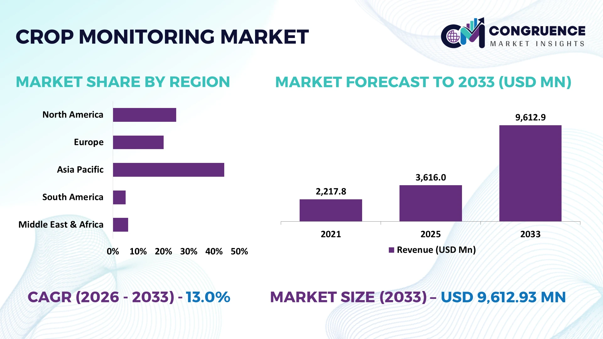
The Global Crop Monitoring Market was valued at USD 3616 Million in 2025 and is anticipated to reach a value of USD 9612.93 Million by 2033 expanding at a CAGR of 13% between 2026 and 2033. Growth is driven by satellite crop intelligence, multispectral drones, IoT soil sensing, AI disease detection, variable-rate input management, and farm-labor shortages accelerating precision agriculture deployment.
The United States accounts for an estimated 31% of global crop-monitoring adoption, supported by approximately 240 million acres planted with major field crops and extensive GPS-guided machinery deployment. Auto-steer or guidance technologies cover more than 50% of planted corn and soybean acreage, creating infrastructure for sensor-led monitoring. Brazil provides greater tropical cropping intensity but lower digital penetration among smaller farms. U.S.-China technology tensions and semiconductor supply disruptions have reinforced procurement diversification for drones, GNSS modules, cameras, and agricultural electronics.
Strategically, vendors should integrate satellite, machinery, sensor, and agronomic datasets into interoperable platforms that convert field observations into input-saving decisions.
Market Size & Growth: USD 3.616 billion in 2025 reaches USD 9.613 billion by 2033 at 13%, driven by satellite and AI-enabled agronomy.
Top Growth Drivers: Precision input management 38%, climate-risk monitoring 34%, and agricultural labor constraints 28% lead adoption.
Short-Term Forecast: By 2028, automated scouting can reduce manual field-inspection requirements approximately 25% across digitally managed large farms.
Emerging Technologies: AI vision, hyperspectral imaging, and edge analytics enable crop-stress identification across centimeter-level drone imagery.
Regional Leaders: North America approaches USD 3.3 billion, Asia-Pacific USD 2.9 billion, and Europe USD 2.0 billion as remote monitoring scales.
Consumer/End-User Trends: More than 50% of U.S. corn and soybean acreage uses guidance technology, supporting connected monitoring workflows.
Pilot/Case Example: 2025 AI scouting deployments demonstrated disease-classification accuracy above 90%, accelerating intervention before visible field-wide damage.
Competitive Landscape: Deere holds an estimated 15% position, competing with Trimble, Bayer, CNH, and AGCO across connected agricultural ecosystems.
Regulatory & ESG Impact: EU agricultural policy targets a 50% reduction in chemical pesticide use and risk, strengthening precision-monitoring requirements.
Investment & Funding: USDA climate-smart agriculture programs mobilized more than USD 3 billion, accelerating measurement, verification, and farm-data infrastructure.
Innovation & Future Outlook: Satellite revisit intervals below 5 days increasingly combine with drone and sensor data for continuous field-level intelligence.
The Crop Monitoring Market is shifting from periodic field scouting toward continuous digital observation across cereals, oilseeds, horticulture, specialty crops, and large commercial farms. Satellite imagery, multispectral drones, connected weather stations, AI vision, and soil sensors increasingly combine within unified agronomic workflows. Precision technologies already operate across more than 50% of planted U.S. corn and soybean acreage for selected guidance applications, providing infrastructure for monitoring expansion. Climate volatility and agricultural labor constraints are accelerating automated scouting, creating a transition toward predictive crop intelligence and decision-oriented farm platforms.
Crop monitoring is becoming strategic infrastructure for agricultural competitiveness because input decisions increasingly depend on field-level evidence rather than scheduled scouting. Satellite constellations, machine telemetry, weather feeds, and crop models are converging into decision platforms, while tighter pesticide and nutrient policies strengthen requirements for documented application. Digital agriculture investment is consequently shifting from standalone sensing hardware toward interoperable agronomic intelligence connecting observations with machinery.
Automated imagery can inspect hundreds of hectares per day versus roughly 20–40 hectares through intensive manual scouting, reducing inspection time by more than 70% on large operations. Brazil emphasizes scalable satellite monitoring across extensive soybean and maize acreage, while the Netherlands concentrates technology around high-value, data-intensive production. A commercial grower can combine vegetation-index imagery with sprayer prescriptions, treating stressed zones instead of entire fields and reducing unnecessary passes.
Through 2028, sub-weekly satellite observation, edge AI, and machinery integration will increase monitored acreage while compressing decision cycles from days to hours. Technology providers are investing in agronomic AI, equipment APIs, localized crop models, and partnerships with cooperatives and input distributors. Competitive advantage will belong to platforms that convert heterogeneous field data into timely, auditable actions rather than simply generating imagery.
Fertilizer, crop-protection, and irrigation costs are pushing commercial farms toward field-level monitoring that identifies variability before inputs are applied. Precision guidance already covers more than 50% of planted U.S. corn and soybean acreage for selected operations, while variable-rate systems can reduce fertilizer application approximately 10%–20% where soil and crop variability is significant. Europe’s policy direction toward reducing pesticide use intensifies demand for documented, targeted intervention. Crop-monitoring providers are connecting satellite imagery, scouting applications, soil measurements, and machinery prescriptions to shorten diagnosis-to-treatment workflows. The non-obvious advantage is equipment utilization: identifying affected zones before dispatch prevents unnecessary sprayer or scouting passes. Companies are expanding machine integrations, agronomic partnerships, and prescription-generation capabilities to capture value beyond visualization.
Reliable data transmission remains structurally uneven across agricultural areas, constraining real-time monitoring outside well-connected commercial farms. Rural internet availability can trail urban coverage by more than 20 percentage points in developing agricultural economies, while drone-based multispectral surveys can cost 30%–50% more per hectare than basic satellite monitoring when repeated frequently. India’s fragmented holdings further weaken per-farm economics for dedicated hardware and subscription platforms. Vendors are reducing exposure through offline-first applications, shared-service models, lower-cost satellite packages, and cooperative distribution. The critical commercial constraint is data-transfer economics rather than sensor availability: high-resolution monitoring loses value when imagery cannot reach operators during narrow irrigation or spraying windows. Successful providers therefore design deployment models around local connectivity and farm structure instead of assuming continuous cloud access.
Brazil offers a high-value opportunity because double cropping, extensive soybean and maize production, and weather variability create repeated monitoring requirements across the same land annually. Brazil cultivates more than 45 million hectares of soybeans, while second-crop maize exposes producers to compressed planting windows and greater weather risk. AI models combining satellite imagery with rainfall and crop-stage data can identify emerging stress several days before conventional scouting reaches dispersed fields. Providers are building Portuguese-language agronomy models, cooperative partnerships, and API connections with farm-management systems. By 2028, automated anomaly prioritization can reduce routine scouting workloads by roughly 25%–30%. The less obvious opportunity is monitoring frequency: multi-season production increases annual observations per hectare, improving subscription economics without requiring equivalent expansion in customer acreage.
Long-term scaling depends on converting incompatible imagery, sensor, machinery, weather, and farm-record formats into consistent operational decisions. Commercial farms can operate equipment from three or more machinery brands, while satellite products vary from sub-meter imagery to 10-meter resolution, creating mismatched spatial and temporal datasets. AI disease models exceeding 90% accuracy under controlled datasets can deteriorate materially when transferred across cultivars, climates, or camera conditions. Australian and U.S. farms increasingly expose this interoperability problem as connected machinery fleets expand. Vendors must invest in standardized APIs, geospatial normalization, model retraining, cybersecurity, and agronomic validation. The strategic risk is automation without context: incorrect stress classification can trigger unnecessary field intervention at scale. Durable platforms will combine machine-readable interoperability with localized models and human agronomic oversight.
Higher Frequency Imagery Replaces Snapshots Commercial farms are shifting from occasional satellite checks toward multi-date crop observation as newer constellations provide imagery every 1–5 days. Cloud-filtered optical data combined with radar improves usable observation frequency by roughly 20%–30% in cloudy production zones. Providers are automating image ingestion and field-level change detection, allowing agronomists to prioritize abnormal parcels rather than inspect every field. Companies are expanding satellite partnerships and automated processing pipelines, making monitoring frequency a competitive service metric.
Edge Vision Moves Onto Machinery Cameras and onboard processors are turning tractors, sprayers, and implements into continuous crop-observation platforms. Modern machine-vision systems process imagery within milliseconds and can distinguish plants from background with accuracy exceeding 90% under validated conditions. U.S. equipment manufacturers are embedding cameras and edge computing directly into field operations, reducing dependence on post-season analysis. Technology providers are partnering with machinery OEMs and training larger agronomic datasets, converting normal equipment passes into additional monitoring events without separate scouting deployment.
Radar Monitoring Expands Weather Resilience Synthetic aperture radar is gaining operational importance because cloud cover does not block microwave observation. Radar satellites can monitor fields during day or night, while revisit periods on major constellations reach approximately 6–12 days before multi-satellite processing. This capability strengthens crop surveillance in monsoon-affected India and tropical production areas where optical imagery availability deteriorates seasonally. Analytics companies are fusing radar and optical datasets, improving continuity and reducing monitoring gaps without requiring additional field hardware.
Traceability Extends Monitoring Workflows Crop monitoring increasingly feeds compliance, insurance, procurement, and sustainability verification rather than agronomy alone. Georeferenced platforms can maintain field histories across 100% of enrolled acreage and document planting, crop condition, and land-use change. EU deforestation rules and food-chain traceability requirements are pushing agribusinesses toward auditable geospatial records. Providers are adding historical imagery, boundary verification, and reporting modules. The non-obvious shift is commercial: monitoring data now supports supplier qualification and risk management beyond farm-level production decisions.
Satellite Monitoring represents the leading type with an estimated 34% market share because one platform can observe thousands of dispersed fields without installing physical infrastructure. Modern optical satellites provide 10-meter-class freely available imagery, while commercial systems offer substantially finer resolution for targeted analysis. Remote Sensing complements satellite workflows by converting spectral measurements into vegetation, moisture, and stress indicators. Ground Monitoring remains important for physical verification, while Sensor-Based Monitoring supplies localized soil and microclimate measurements that satellite imagery cannot directly capture.
IoT Monitoring is the fastest-growing type as farms connect soil probes, weather stations, irrigation controllers, and equipment telemetry into continuous decision workflows. Connected deployments can reduce manual data-collection requirements by approximately 20%–30%. Drone Monitoring occupies a high-resolution role where centimeter-scale imagery is required for localized inspection. Vendors are therefore investing in interoperable dashboards, device connectivity, automated alerts, and satellite-IoT data fusion. Investment is shifting toward integrated monitoring stacks that balance broad coverage with field-level verification rather than standalone sensing technologies.
Crop Health leads applications with an estimated 30% share because vegetation condition provides the central decision layer connecting imagery with field intervention. Multispectral monitoring tracks canopy vigor and stress before problems become uniform across fields, enabling managers to prioritize inspection. Soil Monitoring and Weather Monitoring provide underlying environmental context, while Irrigation Management converts moisture and crop-condition information into scheduling decisions. Yield Forecasting remains strategically important for procurement, logistics, and harvest planning, particularly across large commodity production systems.
Disease Detection is the fastest-growing application as AI vision increasingly identifies symptomatic leaves and canopy patterns with validated classification accuracy above 90% in controlled datasets. Pest Detection is progressing similarly where traps, cameras, and imagery support targeted surveillance. Companies are integrating computer vision, localized disease libraries, weather variables, and automated alerting instead of selling imagery alone. Business value increasingly depends on converting detected anomalies into intervention priority. This favors platforms combining Crop Health monitoring with diagnostic layers while preserving agronomic validation before treatment decisions.
Large Farms represent the leading end-user group with an estimated 39% share because extensive acreage improves the economics of satellite subscriptions, connected sensors, drones, and integrated machinery data. Monitoring thousands of hectares creates measurable value from centralized anomaly detection and remote field prioritization. Agribusinesses use similar platforms for contracted-acreage oversight, procurement forecasting, and production risk management. Research Institutes and Government Agencies concentrate on experimental validation, national crop assessment, and food-security surveillance rather than farm-level commercial deployment.
Agricultural Cooperatives are the fastest-growing end-user as shared purchasing distributes technology costs across multiple producers. Cooperative monitoring can lower per-farm platform expenditure by approximately 15%–25% when imagery, agronomic services, and field equipment are procured collectively. Small Farms gain access through these shared models, while Agricultural Consultants increasingly operate monitoring dashboards across multiple clients. Providers are developing acreage-based subscriptions, cooperative dashboards, consultant portals, and localized support. Competitive positioning is therefore shifting toward multi-farm management capabilities that expand deployment without requiring every producer to maintain dedicated technical infrastructure.
North America accounted for the largest market share at 36.2% in 2025 however, Asia-Pacific is expected to register the fastest growth, expanding at a CAGR of 15.8% between 2026 and 2033.
Connected Machinery Deepens Field Intelligence
North America accounts for approximately 36.2% of global crop-monitoring activity, supported by large commercial farms, mature precision-agriculture infrastructure, extensive satellite coverage, and connected agricultural machinery. U.S. and Canadian operators increasingly combine equipment telemetry, aerial imagery, weather stations, and agronomic records within centralized farm-management environments. More than 50% of planted U.S. corn and soybean acreage already uses guidance technologies for selected field operations, providing a digital foundation for automated crop observation. Equipment manufacturers are embedding cameras, connectivity, and onboard computing into tractors and implements, allowing routine field passes to generate agronomic information. Enterprise providers are consequently prioritizing machine-data interoperability and dealer-supported digital services, turning crop monitoring from a separate scouting function into an integrated component of equipment operations and seasonal farm planning.
United States Market Outlook: The United States combines extensive commercial acreage with established precision-equipment dealerships, agricultural research institutions, and high-resolution geospatial infrastructure. Approximately 27% of U.S. farms use precision-agriculture practices, with adoption substantially higher among large operations. Technology providers therefore gain scale by integrating monitoring tools with existing machinery, agronomic software, crop insurance workflows, and dealer networks rather than building standalone field-service infrastructure.
Compliance Converts Data Into Farm Evidence
Europe represents approximately 24.1% of global crop-monitoring deployment, with Germany, France, Italy, Spain, and the Netherlands supporting advanced precision farming and agricultural digitization. Monitoring platforms increasingly provide evidence for nutrient planning, pesticide documentation, environmental schemes, and Common Agricultural Policy compliance alongside agronomic analysis. Sentinel-2 imagery provides multispectral observations at resolutions down to 10 meters, giving farms and service providers standardized geospatial infrastructure without proprietary satellite ownership. Agricultural software companies are integrating parcel boundaries, satellite indicators, machinery records, and compliance documentation into unified workflows. This regulatory-operational convergence changes purchasing criteria: traceable field histories and standardized reporting now carry greater enterprise value. Providers are responding with API integration, automated documentation, and localized agronomic models designed around European cropping systems and farm-management requirements.
France Market Outlook: France combines approximately 27 million hectares of utilized agricultural area with major cereals, oilseeds, vineyards, and horticultural production. Its parcel-based agricultural administration creates a strong environment for geospatial monitoring. Crop-monitoring vendors can differentiate through field-boundary automation, crop classification, regulatory documentation, and specialty-crop analytics tailored to highly varied production systems rather than relying solely on broad-acre imagery.
Farm Digitization Moves Toward Service Models
Asia-Pacific accounts for approximately 27.5% of global activity, with China, India, Australia, and Japan presenting sharply different deployment economics. China combines agricultural drones, domestic satellite systems, connected machinery, and large-scale digital platforms, while Japan emphasizes automation for labor-constrained farming. India increasingly deploys remote sensing through government programs, insurers, agritech companies, and farmer organizations because fragmented holdings limit individual hardware ownership. The country has more than 140 million operational agricultural holdings, making shared monitoring and service-based delivery commercially important. Providers are expanding drone-as-a-service networks, mobile agronomy applications, local-language interfaces, and satellite analytics rather than depending exclusively on farm-owned technology. This operating model expands addressable acreage while reducing upfront equipment requirements, positioning service orchestration as a critical competitive capability across fragmented agricultural markets.
China Market Outlook: China combines approximately 120 million hectares of cultivated land with domestic BeiDou positioning, agricultural-drone manufacturing, telecommunications infrastructure, and large digital platforms. Drone spraying and field mapping have reached millions of hectares annually, creating a substantial installed operating ecosystem. Providers benefit from linking monitoring algorithms directly with locally manufactured drones, autonomous machinery, and cloud-based agricultural services.
Commodity Agriculture Rewards Remote Visibility
South America contributes approximately 8.0% of global crop-monitoring activity, with Brazil and Argentina generating the strongest commercial demand. Large soybean, maize, sugarcane, cotton, and wheat operations create strong economics for satellite surveillance because farms can span thousands of hectares across dispersed locations. Brazil plants more than 45 million hectares of soybeans, making rapid identification of emergence variability, weather damage, and harvest readiness operationally valuable. Agribusinesses increasingly integrate monitoring with crop procurement, credit, insurance, and logistics rather than limiting deployment to agronomy. Mobile coverage outside established farming corridors remains uneven, encouraging cloud platforms to support delayed synchronization and low-bandwidth workflows. Technology companies are expanding Portuguese and Spanish analytics, cooperative partnerships, and local agronomic teams to convert remote observations into field-specific recommendations.
Brazil Market Outlook: Brazil’s multiple-cropping systems create unusually high monitoring intensity because soybean harvest is frequently followed by second-crop maize on the same land. Mato Grosso alone cultivates millions of hectares across these rotations. Vendors can improve platform economics by supporting multiple seasonal observation cycles per customer while integrating weather, planting dates, crop-stage models, and commodity supply-chain requirements.
Water Scarcity Prioritizes Precision Observation
Middle East & Africa represents approximately 4.2% of global crop-monitoring deployment, with Saudi Arabia, the UAE, South Africa, Kenya, and Morocco forming important adoption centers. Water constraints make crop condition and irrigation monitoring particularly valuable in Gulf agriculture, while African deployments increasingly use satellites and mobile platforms to cover geographically dispersed farms without extensive ground infrastructure. Agriculture consumes approximately 70% of global freshwater withdrawals, making irrigation intelligence strategically important in water-stressed production systems. Governments, development institutions, and agritech providers are deploying earth observation for drought assessment, food-security monitoring, and irrigation management. Commercial providers are responding through cloud-based geospatial services, localized crop models, and partnerships with irrigation operators and public agencies, prioritizing scalable remote observation where sensor infrastructure remains economically difficult.
South Africa Market Outlook: South Africa combines commercial maize, citrus, grape, and horticultural operations with relatively developed agricultural services and telecommunications infrastructure. Commercial farms increasingly use imagery and weather intelligence to manage irrigation and export-quality production. High-value fruit supply chains particularly reward early identification of canopy variability because quality deviations can directly affect packhouse utilization and export-grade yields.
Deere competes with CNH and AGCO through machinery-integrated crop intelligence, while Trimble and Bayer challenge equipment-led ecosystems with geospatial and agronomic platforms. The top five players hold an estimated 44% combined share, leaving specialist satellite, drone, and analytics providers meaningful application space. Machinery-linked platforms benefit from installed equipment relationships, while independent software vendors can reduce deployment costs by approximately 20% through hardware-neutral integration. AI-assisted scouting cuts inspection workloads around 25%, making automation another competitive lever. Companies are acquiring software capabilities, opening APIs, partnering with satellite providers, and integrating prescriptions directly into field equipment. Competition is shifting from standalone imagery toward closed-loop systems connecting detection, agronomic interpretation, and execution. Data interoperability, localized crop models, dealer access, and multi-season training datasets create substantial entry barriers. Winning requires accurate field intelligence, seamless equipment integration, scalable agronomic support, and measurable operational savings across customers’ existing technology stacks.
Deere & Company
Trimble
Bayer
CNH Industrial
AGCO Corporation
Topcon Corporation
Hexagon AB
Planet Labs
EOS Data Analytics
CropX Technologies
Taranis
Prospera Technologies
Sentera
Agremo
Current crop monitoring technology is moving toward thermal imaging, LiDAR, and GNSS-corrected mapping that quantify canopy temperature, plant height, and field variability. Thermal cameras identify water stress before visible symptoms, while RTK positioning delivers approximately 2-centimeter accuracy. Compared with manual georeferencing, automated spatial registration improves mapping productivity by roughly 30%. Adoption is strongest among commercial farms and research operations requiring repeatable measurements.
Emerging platforms combine digital twins, crop-growth simulation, and generative agronomic interfaces. Digital twins synchronize field observations with phenology models, enabling scenario testing for irrigation, nutrition, and harvest timing. Model-assisted scheduling can improve water-use efficiency by approximately 15% where calibrated data is available. Enterprise deployment is expanding through farm-management platforms connecting operational records with predictive models, giving agribusinesses faster planning cycles and standardized multi-farm oversight.
Between 2026 and 2028, hyperspectral sensors and foundation models will push monitoring from stress detection toward biochemical interpretation. Hyperspectral systems capture hundreds of spectral bands versus fewer than ten on conventional multispectral cameras, improving differentiation of nutrient, disease, and physiological signals. Automated model retraining can reduce analytical turnaround approximately 20%. Technology providers integrating sensor calibration, crop models, and decision software will gain advantage because actionable diagnosis, not imagery volume, will determine commercial platform value.
January 2025 John Deere unveiled second-generation autonomy technology combining computer vision, AI, and cameras for agricultural machines. The system targets labor-constrained operations and expands autonomous field execution, strengthening Deere’s connected monitoring and machine-intelligence ecosystem across commercial production agriculture.
June 2025 Planet upgraded Soil Water Content resolution from 100 meters to 20 meters while increasing observations 30–60%. The improvement delivers finer, more frequent moisture intelligence, strengthening irrigation monitoring and field-level agronomic decisions across commercial cloud-constrained production environments.
September 2025 CropX acquired Acclym, its seventh strategic acquisition, adding a platform deployed across millions of hectares. The transaction expands crop and sustainability monitoring for food companies, connecting field-level agronomic intelligence with enterprise procurement, resilience, and ESG workflows.
October 2025 Taranis and Syngenta formalized an AI crop-intelligence partnership after their 2025 collaboration, with expansion across the Midwest planned for 2026. The program combines leaf-level monitoring with crop protection expertise, reducing manual scouting and prioritizing higher-risk fields.
The report evaluates Satellite Monitoring, Drone Monitoring, Sensor-Based Monitoring, IoT Monitoring, Ground Monitoring, and Remote Sensing across Crop Health, Yield Forecasting, Irrigation Management, Pest Detection, Soil Monitoring, Disease Detection, and Weather Monitoring. Satellite Monitoring represents approximately 34% of type demand, while Crop Health accounts for roughly 30% of application deployment, providing benchmarks for technology and portfolio planning.
End-user coverage includes Large Farms, Small Farms, Agricultural Cooperatives, Agribusinesses, Research Institutes, Government Agencies, and Agricultural Consultants across five major regions. Technology analysis examines thermal imaging, LiDAR, hyperspectral sensing, digital twins, RTK positioning, crop simulation, and predictive analytics. The 2026–2033 scope supports investment prioritization, geographic expansion, partnership strategy, platform positioning, and identification of emerging opportunities in automated diagnosis, enterprise crop intelligence, and digitally coordinated agricultural operations.
| Report Attribute/Metric | Report Details |
|---|---|
Market Revenue in 2025 | USD 3616 Million |
Market Revenue in 2033 | USD 9612.93 Million |
CAGR (2026 - 2033) | 13% |
Base Year | 2025 |
Forecast Period | 2026 - 2033 |
Historic Period | 2021 - 2025 |
Segments Covered | By Type
By Application
By End-User
|
Key Report Deliverable | Revenue Forecast, Growth Trends, Market Dynamics, Segmental Overview, Regional and Country-wise Analysis, Competition Landscape |
Region Covered | North America, Europe, Asia-Pacific, South America, Middle East, Africa |
Key Players Analyzed | Deere & Company, Trimble, Bayer, CNH Industrial, AGCO Corporation, Topcon Corporation, Hexagon AB, Planet Labs, EOS Data Analytics, CropX Technologies, Taranis, Prospera Technologies, Sentera, Agremo |
Customization & Pricing | Available on Request (10% Customization is Free) |