
Reports
The Global Airborne LiDAR Market was valued at USD 1,165.0 Million in 2025 and is anticipated to reach a value of USD 3,664.1 Million by 2033 expanding at a CAGR of 15.4% between 2026 and 2033. Growth is being driven by high-resolution terrain mapping, corridor surveying, forest-carbon measurement, coastal monitoring, and infrastructure digitalization requiring faster 3D data acquisition.
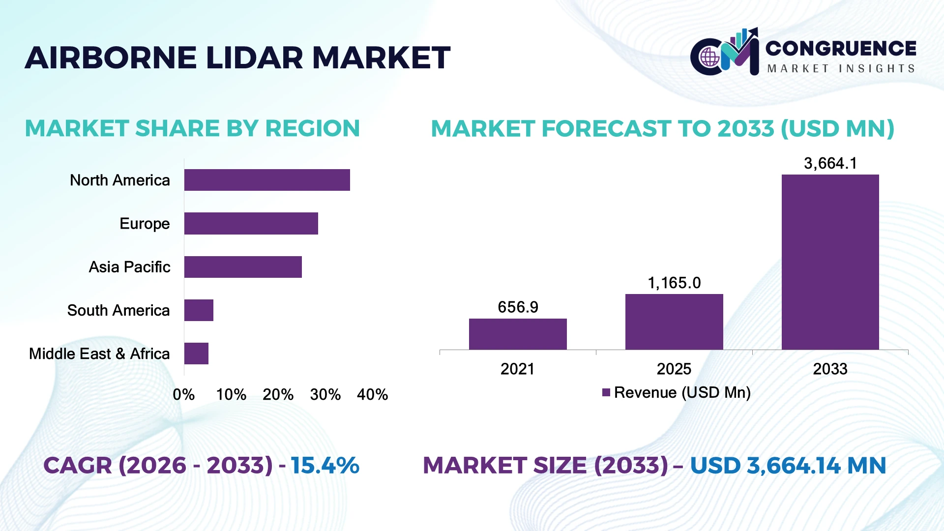
The United States remains the dominant national market, supported by extensive deployment across utilities, transportation, defense, forestry, and disaster-management programs. North American operators account for an estimated 35–40% of commercial airborne LiDAR activity, compared with roughly 25% in Europe. Modern full-waveform and bathymetric systems can improve usable point-cloud capture by 15–25% versus legacy survey workflows. Geopolitical emphasis on critical-infrastructure resilience is also increasing demand for rapid terrain and corridor intelligence.
Strategic priority is shifting toward multi-sensor platforms, automated classification, and recurring geospatial-data services rather than standalone survey flights.
Market Size & Growth: USD 1.17 billion in 2025 to USD 3.66 billion by 2033 at 15.4% CAGR, driven by infrastructure mapping and high-resolution geospatial intelligence.
Top Growth Drivers: Infrastructure mapping 34%, forestry 22%, corridor surveying 18%.
Short-Term Forecast: By 2028, automated point-cloud classification can reduce processing time 30–40% and improve survey turnaround 20–30%.
Emerging Technologies: Full-waveform LiDAR, bathymetric LiDAR, AI classification, and LiDAR-camera fusion are expanding high-precision mapping capabilities.
Regional Leaders: North America represents roughly 38% of activity, Europe 25%, and Asia-Pacific 22%, with drone-airborne integration accelerating deployments.
Consumer/End-User Trends: Utilities and transportation collectively account for more than 40% of recurring commercial surveying requirements.
Pilot/Case Example: 2025 corridor-mapping deployments using LiDAR and multispectral sensors achieved approximately 20–30% faster terrain-data processing than manual classification workflows.
Competitive Landscape: Leading providers include Leica Geosystems, RIEGL, Teledyne Optech, YellowScan, and GeoCue, competing through sensor range, accuracy, processing, and platform integration.
Regulatory & ESG Impact: Carbon mapping and environmental monitoring applications are increasing demand for forest and wetland datasets, with automated classification reducing manual interpretation requirements by 30% or more.
Investment & Funding: Multi-million-dollar investments are concentrating on sensor miniaturization, AI processing, bathymetric capabilities, and integrated airborne survey platforms.
Innovation & Future Outlook: Next-generation systems will combine LiDAR, hyperspectral imaging, GNSS/IMU, and AI analytics, shifting competition toward complete geospatial intelligence workflows.
The Airborne LiDAR Market is expanding beyond conventional topographic surveying into utility corridor management, coastal mapping, forestry analytics, mining, flood-risk assessment, and infrastructure digital twins. High-density point clouds increasingly support automated feature extraction, while LiDAR-camera fusion improves classification accuracy and reduces post-processing workloads by approximately 20–30%. In 2026, demand is increasingly linked to infrastructure resilience, wildfire monitoring, and critical-asset mapping. Operators are therefore investing in compact sensors, automated workflows, and multi-sensor platforms that generate more usable intelligence per flight hour, setting the foundation for the strategic shift toward integrated geospatial services.
The Airborne LiDAR Market is becoming strategically important because infrastructure owners increasingly require accurate three-dimensional asset intelligence before committing capital to transportation, utilities, mining, forestry, and climate-resilience projects. The market is shifting from one-time survey contracts toward repeat data acquisition, digital twins, and analytics-enabled geospatial services. In 2026, critical-infrastructure resilience and environmental monitoring are strengthening demand for rapid, high-density terrain information.
Modern full-waveform and multi-sensor LiDAR platforms can improve usable data capture by approximately 15–25% compared with legacy survey configurations, while AI-assisted classification can reduce post-processing labor by 30–40%. North America retains the strongest commercial deployment base, while Europe emphasizes environmental and infrastructure applications and Asia-Pacific is accelerating corridor, urbanization, and resource-mapping deployments.
Over the next 2–3 years, automated classification, sensor fusion, and cloud-based processing should shorten survey-to-delivery cycles by 20–30%. A practical deployment model combines LiDAR with RGB or multispectral imaging to map transmission corridors while simultaneously identifying vegetation encroachment and structural assets. Providers are consequently prioritizing sensor integration, software partnerships, and recurring data services. Competitive advantage will belong to operators that deliver actionable geospatial intelligence faster, not simply higher point density.
Infrastructure modernization is increasing demand for airborne LiDAR as transportation agencies, utilities, forestry operators, and defense organizations require high-density 3D datasets for asset planning and monitoring. A 2025 U.S. transportation survey found 49% of state DOTs had used LiDAR for more than a decade, while 70.6% reported safety benefits and 68.8% cited time-efficiency gains. AI-assisted classification is further reducing manual point-cloud processing requirements. The U.S. push toward scalable beyond-visual-line-of-sight aerial operations is expanding the addressable workflow for mapping and inspection. Providers are responding with integrated LiDAR-camera systems, automated classification, and cloud processing. The strategic shift is from selling sensor capacity toward delivering faster survey-to-decision workflows.
High system costs, specialist expertise, and large point-cloud workloads continue to constrain broader deployment, particularly among smaller surveying firms. A 2025 U.S. DOT survey identified high initial costs and specialized training as persistent adoption barriers, while integration of large datasets into existing systems remains difficult. Around 49% of state DOTs had already adopted LiDAR for more than a decade, leaving newer users facing steeper capability-building requirements. Data storage, QA/QC, GNSS/IMU calibration, and processing infrastructure also increase project overhead. Companies are mitigating these pressures through equipment leasing, outsourced processing, modular sensor packages, and software automation. The operational priority is shifting from maximizing point density to maximizing usable information per flight hour and reducing downstream processing expenditure.
The strongest opportunity is the convergence of airborne LiDAR with AI, multispectral imaging, hyperspectral sensing, and increasingly autonomous aerial platforms. A 2025 aerial-survey industry report found 46% of respondents rated LiDAR very important or essential to their workflows, while 23% had not yet used it, indicating substantial conversion potential. AI-based classification can reduce repetitive interpretation workloads by roughly 30–40%, creating measurable productivity gains for utilities, forestry, and corridor mapping. Emerging BVLOS frameworks are also creating a pathway toward more scalable aerial surveying. Companies are investing in compact sensors, multi-platform integration, and automated analytics. The non-obvious opportunity is recurring asset monitoring, where the same geospatial dataset becomes an operational intelligence service rather than a one-time survey deliverable.
Long-term growth depends on solving fragmented data workflows, inconsistent QA/QC standards, cybersecurity exposure, and shortages of skilled LiDAR analysts. U.S. transportation agencies report substantial variation in LiDAR adoption and data-management practices, while 68.8% cite time efficiency and 70.6% safety improvements as established benefits. The challenge is therefore not proving LiDAR value but converting isolated survey programs into standardized enterprise workflows. Large point clouds must integrate reliably with GIS, digital twins, asset-management platforms, and engineering systems without degrading accuracy. Companies are responding through cloud-native processing, machine-learning classification, interoperable data standards, and workforce training. The strategic pressure is to build repeatable processing pipelines that maintain survey accuracy while supporting higher flight frequency and larger geographic coverage.
AI Classification Gains Momentum AI-assisted point-cloud classification is moving into routine survey workflows, with automated processing capable of reducing manual interpretation workloads by roughly 30–40%. U.S. transportation agencies are increasingly evaluating machine learning for LiDAR processing, pushing providers toward embedded analytics rather than standalone sensor hardware.
Drone LiDAR Adoption Accelerates Mid-range aerial LiDAR systems are becoming easier to deploy repeatedly, with 46% of surveyed aerial-mapping users rating LiDAR very important or essential while 23% reported no prior use. Companies are responding with lighter payloads, simplified workflows, and integrated positioning systems.
BVLOS Surveying Enters Transition U.S. regulatory development is creating a clearer pathway for scalable beyond-visual-line-of-sight aerial surveying. Proposed operating structures address mapping and inspection while introducing controls around fleet size and operational oversight. Providers are consequently designing systems for repeatable, remotely supervised data acquisition rather than isolated missions.
Bathymetric Processing Gets Smarter New 2026 research is applying physics-driven deep learning to airborne bathymetric LiDAR, with reported image-quality metrics reaching 29.60 dB PSNR and 0.962 SSIM. This strengthens shallow-water and turbid-water mapping capabilities, encouraging providers to combine waveform analytics with environmental and coastal-monitoring workflows.
Topographic LiDAR Maintains the Scale Advantage
Topographic LiDAR is the leading type, accounting for approximately 68% of the global Airborne LiDAR market, supported by extensive deployment in terrain mapping, urban planning, transportation infrastructure, utilities, forestry, and land surveying. Its mature sensor architecture, established GIS compatibility, and ability to cover large areas efficiently give it a clear scalability advantage. Bathymetric LiDAR accounts for roughly 22%, serving hydrographic surveying, coastal engineering, nautical charting, and environmental monitoring, while topo-bathymetric LiDAR represents the remaining 10% and addresses integrated land-water mapping requirements.
Bathymetric and topo-bathymetric systems are gaining strategic importance as coastal resilience, flood assessment, and marine infrastructure programs require higher-resolution elevation data. Their combined adoption is strengthening, with specialized applications representing roughly 30% of demand. Companies are therefore increasing investment in green-wavelength systems, multi-sensor payloads, higher pulse rates, and integrated processing platforms. The investment priority is shifting from standalone LiDAR hardware toward sensor combinations that deliver broader geographic coverage and reduce the need for separate terrestrial and hydrographic surveys.
A 2025 airborne-mapping industry survey found 46% of respondents considered LiDAR very important or essential to their workflows, confirming its transition from specialist surveying equipment toward routine geospatial infrastructure.
Wide-Area Mapping Anchors Deployment Scale
Wide-area mapping leads the application landscape with approximately 38% market share, reflecting concentrated use in urban mapping, national terrain programs, infrastructure planning, flood-risk assessment, and large-area digital elevation modeling. Its dominance comes from the ability to generate consistent, high-density datasets across extensive geographic areas, reducing repeated ground-survey requirements. Corridor mapping follows at approximately 31%, supported by roads, railways, transmission lines, pipelines, and other linear infrastructure programs.
Natural-resource applications represent about 19%, while specialized applications account for roughly 12%. Corridor mapping is emerging as the fastest-growing use case as infrastructure operators increasingly shift from one-time surveys toward recurring asset monitoring and vegetation-management workflows. Automated feature extraction and AI-enabled change detection can reduce manual point-cloud interpretation workloads by approximately 30–40%. Companies are responding by expanding recurring mapping contracts, integrating LiDAR with imagery and digital twins, and deploying UAV-supported surveys for localized updates. Demand is becoming operationally critical where infrastructure owners require frequent terrain, clearance, and asset-condition intelligence.
A 2025 airborne-mapping industry assessment found 46% of respondents rated LiDAR very important or essential to their workflows, highlighting established operational dependence while leaving substantial room for adoption expansion.
Civil Engineering Leads Infrastructure Deployment
Civil engineering is the dominant end-user, representing approximately 29% of Airborne LiDAR demand, driven by road development, terrain modeling, construction planning, digital elevation models, and large-scale infrastructure surveys. Its concentration reflects high-value projects requiring precise elevation data and repeatable surveying workflows. Aerospace and defense contribute around 23%, where rapid terrain intelligence, surveillance, mission planning, and operational mapping prioritize accuracy and acquisition speed.
Forestry and agriculture account for approximately 17% and represent the fastest-growing end-user group as operators adopt LiDAR for canopy characterization, biomass estimation, vegetation monitoring, and precision land management. Transportation contributes nearly 15%, while mining and other specialized users comprise the balance. Forestry workflows increasingly combine LiDAR with multispectral imagery and automated analytics, reducing field-based measurement requirements by an estimated 20–30%. Companies are responding through sector-specific software, subscription-based geospatial services, equipment partnerships, and integrated sensor packages. Competitive positioning is shifting toward application-specific intelligence and recurring data services rather than standalone airborne scanning equipment.
A 2025 airborne-mapping industry assessment found LiDAR was rated very important or essential by 46% of respondents, reinforcing its role in recurring professional workflows across engineering, mapping, and resource-management applications.
North America accounted for the largest market share at 35.2% in 2025 however, Asia-Pacific is expected to register the fastest growth, expanding at a CAGR of 17.8% between 2026 and 2033.

Infrastructure digitization and high-density mapping strengthen airborne deployment
North America remains the leading Airborne LiDAR market, supported by extensive transportation surveying, utility corridor mapping, forestry management, flood-risk assessment, and defense applications. The United States represents the regional demand center, accounting for more than 80% of North American LiDAR revenue, while airborne systems represented over 44% of U.S. LiDAR revenue in 2024. Federal infrastructure modernization and expanding UAV-based surveying are increasing demand for repeatable high-resolution datasets. Companies are strengthening aircraft-mounted and UAV-compatible portfolios, integrating LiDAR with photogrammetry, GNSS/IMU systems, and automated point-cloud processing. Canada is gaining strategic importance through forestry, pipeline, wildfire, and remote-terrain applications, while U.S. providers retain an advantage in large-scale infrastructure contracts.
United States Market Outlook: The United States is the region's principal Airborne LiDAR deployment hub, supported by transportation agencies, utilities, engineering firms, defense programs, and large-scale environmental mapping. Airborne LiDAR held approximately 50.7% of the U.S. LiDAR market in 2025, reflecting its strong fit for wide-area terrain acquisition. Continued highway modernization, floodplain mapping, forestry monitoring, and digital-twin development are sustaining demand for high-throughput airborne platforms.
Regulatory mapping and environmental intelligence reshape procurement
Europe represented approximately 28.4% of the global Airborne LiDAR market in 2025, supported by national topographic mapping, flood-risk management, environmental monitoring, transport modernization, and offshore-energy development. Germany, France, and the United Kingdom form the principal deployment centers, with Germany accounting for about 29.4% of Europe's broader LiDAR market. European buyers increasingly prioritize interoperable geospatial datasets that support infrastructure planning, environmental compliance, and digital-twin applications. Offshore wind development is also creating specialized demand for aerial and marine surveying capabilities. Companies are responding through sensor fusion, automated post-processing, and bundled hardware-software services, while supply-chain diversification is reducing dependence on single-component sources.
Germany Market Outlook: Germany holds the strongest strategic position in Europe because of its automotive engineering base, industrial automation ecosystem, precision manufacturing capabilities, and expanding digital-infrastructure programs. The country's LiDAR market reached approximately USD 76.1 million in 2025, with deployment extending beyond automotive applications into industrial mapping, infrastructure inspection, robotics, and digital-twin development. These capabilities support demand for high-accuracy airborne datasets and advanced processing platforms.
Infrastructure expansion and geospatial modernization accelerate adoption
Asia-Pacific is emerging as the highest-growth Airborne LiDAR market as China, Japan, India, South Korea, and Southeast Asian economies expand transportation infrastructure, smart-city programs, renewable-energy assets, forestry monitoring, and disaster-management capabilities. China is positioned to become the largest national LiDAR market by 2033, while India is strengthening demand through highway construction, rail modernization, urban mapping, and utility planning. Large geographic coverage requirements favor airborne acquisition over labor-intensive ground surveys. Companies are expanding local partnerships, UAV-compatible systems, and cloud-based processing to reduce deployment complexity. The strategic opportunity is particularly strong in infrastructure corridors where a single airborne mission can replace multiple localized surveys and generate reusable datasets for engineering, asset management, and environmental assessment.
China Market Outlook: China represents the region's most significant strategic market because of its large-scale infrastructure programs, advanced manufacturing ecosystem, surveying capacity, and expanding digital-geospatial infrastructure. Government-backed transportation, urban-development, ecological monitoring, and disaster-management projects create substantial requirements for high-density elevation datasets. Domestic technology development also supports faster localization of sensors and processing systems. Companies targeting China are increasingly emphasizing integrated platforms, local service networks, and automated analytics to compete effectively across large infrastructure and environmental programs.
Forest intelligence and infrastructure mapping expand deployment depth
South America's Airborne LiDAR demand is concentrated in Brazil, where forestry, environmental monitoring, mining, energy infrastructure, and transportation projects require accurate terrain and vegetation datasets. Brazil's public forestry-monitoring infrastructure already uses airborne LiDAR to characterize terrain, forest cover, tree height, and density across concession areas. Large-scale Amazon mapping demonstrates the technology's ability to support biomass estimation and conservation planning, with an airborne LiDAR database covering approximately 360,000 km². Companies are therefore targeting forestry intelligence, carbon-stock measurement, transmission-line surveys, and mining development rather than relying solely on conventional cartographic projects. The primary operational constraint remains the cost and logistics of surveying remote terrain, encouraging providers to combine fixed-wing aircraft, UAVs, satellite imagery, and automated analytics.
Brazil Market Outlook: Brazil is the region's most strategically significant Airborne LiDAR market because of its extensive forest resources, mining activity, agricultural geography, and large infrastructure footprint. Government forestry programs use airborne LiDAR to generate detailed terrain and vegetation information, demonstrating institutional acceptance beyond commercial surveying. The Amazon has already been mapped using airborne LiDAR across roughly 360,000 km² in major biomass research, reinforcing its value for carbon assessment, conservation planning, and resource management.
Megaproject mapping and infrastructure modernization drive adoption
Middle East & Africa is developing as a specialized Airborne LiDAR market centered on large infrastructure programs, urban expansion, mining, renewable-energy projects, environmental monitoring, and defense applications. Saudi Arabia and the United Arab Emirates are the principal investment centers, where smart-city development, transportation corridors, utilities, and large-scale construction require high-resolution terrain and asset data. LiDAR-supported digital-twin workflows are increasingly integrated into engineering and geospatial planning, improving coordination across complex projects. African demand remains more application-specific, particularly in mining, forestry, watershed management, and infrastructure planning. Companies are responding with aircraft-based mapping services, UAV-compatible platforms, and outsourced processing models that reduce upfront equipment requirements. The region's strategic advantage lies in large project sizes, while remote terrain and specialist workforce requirements remain important deployment considerations.
Saudi Arabia Market Outlook: Saudi Arabia is the region's strongest strategic market due to large-scale urban development, transportation expansion, renewable-energy projects, and digitally managed infrastructure programs. Airborne LiDAR supports terrain modeling, construction planning, corridor surveys, utility mapping, and digital-twin development across geographically extensive projects. The country's emphasis on large integrated developments favors providers capable of delivering rapid, high-density datasets and combining LiDAR with imagery and automated analytics. Companies with local project partnerships, regional processing capacity, and end-to-end geospatial services are best positioned to capture institutional and infrastructure-led demand.
Hexagon’s Leica Geosystems competes with RIEGL and Teledyne Optech at the premium airborne-sensor level, while YellowScan and Phoenix LiDAR Systems target agile UAV deployments and service-led providers such as Fugro compete through project execution. The top five players are estimated to control roughly 55% of system value, leaving meaningful room for specialist suppliers. Competition centers on acquisition speed, point density, integration and total mission cost: leading systems now deliver 2–5× higher collection rates, while hybrid platforms can reduce separate flight requirements by 15–30%. Players are expanding through integrated LiDAR-imaging platforms, distributor networks, software ecosystems and strategic partnerships. The competitive shift is moving from sensor specifications toward complete survey workflows, including edge processing, automated classification and digital-twin outputs. High capital requirements, calibration expertise and established geospatial relationships remain major entry barriers. Winning requires superior data quality, faster processing, reliable integration and application-specific service economics. Providers combining capabilities will capture premium contracts.
Hexagon AB (Leica Geosystems)
RIEGL Laser Measurement Systems
Teledyne Technologies Incorporated
YellowScan
Phoenix LiDAR Systems
Fugro N.V.
NV5 Global, Inc.
Woolpert, Inc.
AAM Pty Ltd.
COWI A/S
Bluesky International Ltd.
GeoFly GmbH
Merrick & Company
DIELMO 3D
Airborne LiDAR technology is shifting from standalone laser scanners toward hybrid sensor architectures combining LiDAR, RGB/NIR imaging, GNSS/IMU and automated processing. Single-photon systems are disruptive for country-scale mapping: platforms can collect more than 14 million measurements per second, over five times the collection rate of traditional linear-mode LiDAR. This improves survey throughput, reduces flight hours and strengthens the economics of national mapping programs.
Edge computing and waveform digitization are also moving processing closer to acquisition. Teledyne’s Galaxy Edge targets a 20–50% reduction in collection costs, while RIEGL’s integrated systems combine LiDAR, imaging and navigation data within one workflow. Adoption is strongest among infrastructure, utility, forestry and geospatial-service operators that need repeatable corridor datasets. Hybrid acquisition can reduce separate flight requirements by roughly 15–30%, giving vertically integrated providers an advantage.
From 2026–2028, AI-assisted classification, automated change detection, digital twins and compact UAV payloads will become more important than sensor specifications. New hybrid workflows can deliver roughly 30% higher acquisition efficiency than previous-generation configurations in urban mapping. Competitive beneficiaries will be providers controlling sensor, software and analytics layers, while service companies gain from faster turnaround and recurring monitoring contracts. Investment should prioritize interoperable platforms, edge processing and automated quality control.
February 2025 Leica Geosystems launched CoastalMapper, combining bathymetric and topographic LiDAR with imaging. The system reaches 1 million bathymetric measurements per second and 2 million topographic measurements, materially increasing coastline survey productivity and expanding integrated hydrographic mapping capacity. Source: leica-geosystems.com
October 2025 RIEGL introduced the VQ-1060 aerial mapping platform for utility corridors, delivering approximately 70 points/m² from 1,500 feet. The system combines multidirectional LiDAR, RGB and multispectral imaging, strengthening single-flight inspection economics for powerline operators and corridor planners. Source: newsroom.riegl.international
July 2024 Teledyne Geospatial launched Galaxy Edge, an airborne LiDAR system with edge processing and super-resolution. The platform targets a 20–50% reduction in collection costs while improving uniform point density, strengthening competitiveness in steep-terrain and corridor mapping projects. Source: teledyneoptech.com
February 2026 YellowScan introduced Venturer, an NDAA-compliant LiDAR system designed for precision UAV missions. The company positioned the platform for secure survey-grade operations, expanding its portfolio for regulated deployments and strengthening access to defense, infrastructure and mapping programs. Source: yellowscan.com
The Airborne LiDAR Market Report covers system types including topographic, bathymetric and topo-bathymetric LiDAR, with application analysis spanning wide-area mapping, corridor mapping, natural-resource management, infrastructure inspection and specialized surveying. End-user coverage includes civil engineering, aerospace and defense, forestry and agriculture, transportation, mining and other geospatial-intensive organizations. The report evaluates sensor configurations, pulse rates, point density, hybrid imaging, GNSS/IMU integration, edge processing and AI-enabled point-cloud analytics.
Regional assessment covers North America, Europe, Asia-Pacific, South America, and Middle East & Africa, highlighting country-level deployment patterns, infrastructure programs and technology adoption. Competitive analysis evaluates 10–14 major participants, while strategic assessment addresses UAV integration, digital twins, recurring monitoring models and supply-chain localization. The study supports equipment investment, geographic expansion, partnership selection, product positioning and technology priorities through 2026–2033.
| Report Attribute/Metric | Report Details |
|---|---|
|
Market Revenue in 2025 |
USD 1,165 Million |
|
Market Revenue in 2033 |
USD 3,664.1 Million |
|
CAGR (2026 - 2033) |
15.4% |
|
Base Year |
2025 |
|
Forecast Period |
2026 - 2033 |
|
Historic Period |
2021 - 2025 |
|
Segments Covered |
By Type
By Application
By End-User
|
|
Key Report Deliverable |
Revenue Forecast, Growth Trends, Market Dynamics, Segmental Overview, Regional and Country-wise Analysis, Competition Landscape |
|
Region Covered |
North America, Europe, Asia-Pacific, South America, Middle East, Africa |
|
Key Players Analyzed |
Hexagon AB (Leica Geosystems), RIEGL Laser Measurement Systems, Teledyne Technologies Incorporated, YellowScan, Phoenix LiDAR Systems, Fugro N.V., NV5 Global, Inc., Woolpert, Inc., AAM Pty Ltd., COWI A/S, Bluesky International Ltd., GeoFly GmbH, Merrick & Company, DIELMO 3D |
|
Customization & Pricing |
Available on Request (10% Customization is Free) |